Storm Brewing?

Our weather may be about to take a turn towards more active conditions, as a major winter storm looms this week.

A Powerful Low Pressure System is Forecast to Impact Southern Manitoba on Tuesday

Monday

Monday

Cloudy. Snow.
-4°C / -8°C

The weather will begin to take a sour turn on Monday, with some initial bands of snow moving through Southern Manitoba. Areas along the International Border could see 5-10cm of snow through the day on Monday, with areas further north receiving 2-5cm. Temperatures will remain in the single digits with gusty north-east winds.

Tuesday

Tuesday

Snow. Blizzard Possible.
-8°C / -15°C

Tuesday is when things could really get ugly. As of Sunday evening, models were suggesting that this winter storm may move into north-western Minnesota on Tuesday evening, with it’s pressure dropping below 1000mb. At the same time, an arctic high is forecast to slide down into Alberta, generating a large pressure difference across the prairies. This pressure difference will generate very strong winds by late Tuesday. If this storm also produces snow in Southern Manitoba on Tuesday as we currently expect, then the combination of that snow and very strong winds will generate blizzard conditions. Total snowfall on Tuesday into Tuesday night could be 10-20cm in Southern Manitoba along with wind speeds of 40-50km/h gusting to 60-70km/h. Travel may become very difficult to impossible by Tuesday night.

Wednesday

Wednesday

Blizzard Ending
-15°C / -20°C

Snow may continue into Wednesday morning, along with the strong winds. If this storm tracks as currently expected we could see blizzard conditions persisting through a good part of Wednesday in Southern Manitoba. The wind should taper off somewhat on Wednesday night, but it will remain breezy on Thursday.

Long Range

The long range forecast is pretty simple – it will be COLD! After this week’s weather system departs on Wednesday we will see arctic air take over, and it will be the coldest airmass so far this season.

Elsewhere in Weather News: November 2nd, 2013

Strong Mid-Latitude Cyclone Whips Europe

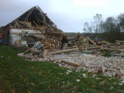
An extremely powerful mid-latitude cyclone sitting off the coast of Scotland affected parts of Europe such as England, Denmark and Germany early last week. Winds were the main threat associated with this storm as gusts reached just below 200km/h in Denmark. The reason why this storm was not classified as a hurricane, even though it had hurricane strength winds, is because hurricanes have a warm core and do not have well defined fronts like low pressures systems do. Here, a mid latitude cyclone was the case as fronts were well defined and other various characteristics did not match one of a hurricane.


A house in Germany was completely destroyed by winds gusting over 100km/h this past week. (Souce: Christiane Boose)

In total, 15 people died from this storm, most due to falling trees. This storm left about 500,000 people without power as trees snapped like twigs and fell on power lines. Off France’s coast waves as high as 5-6m were reported and about 1,300 flights were grounded because of the strong winds.

These very powerful low pressure systems are not unheard of for Europe, though storms with gusts of this intensity do not occur on a yearly basis. This low has since moved off into Russia and is no longer affecting the region. Gusty conditions are expected to return to the UK this weekend as an active pattern, which is not out of the usual for this time of the year, continues.

In other weather news, an unusually strong typhoon (Krosa) has spun up and as of Friday night was of category three intensity. Conditions are not particularly favourable for further development in the South China Sea and the typhoon should gradually weaken as it drifts towards Vietnam.

Elsewhere in Weather News: December 15th, 2012

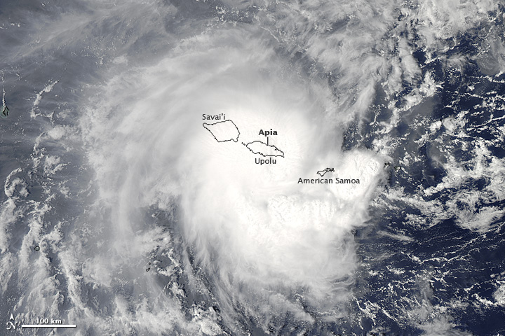
Tropical cyclone Evan struck the Samoan Islands on December 13, bringing strong winds and heavy rain to the area.

NASA's Aqua satellite captured this image of Evan as it struck Samoa

NASA’s Aqua satellite captured this image of Evan as it struck Samoa (Source: http://earthobservatory.nasa.gov/NaturalHazards/view.php?id=79989&src=nha)

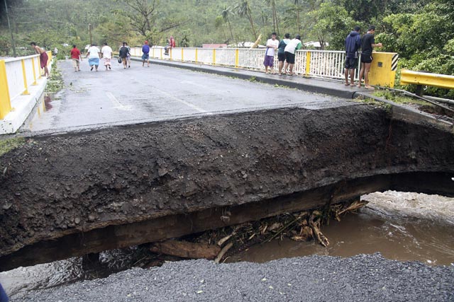
Evan was a category 1 cyclone when it struck the Samoan Islands region on Thursday, with maximum sustained winds of 144km/h. The storm came onshore near Apia, the capital of Samoa, and the country’s largest city (population 37,708). The cyclone destroyed buildings, ripped up trees, and took down phone, internet, and electricity services across Samoa. In addition, the heavy rain generated by Evan caused widespread flooding. The death toll from Evan is at least 2, with the cyclone being called the worst in many years by local residents.

People walk over a destroyed bridge in Samoa's capital Apia, Friday, Dec. 14, 2012

People walk over a destroyed bridge in Samoa’s capital Apia, Friday, Dec. 14, 2012 (Source: http://www.wunderground.com/blog/JeffMasters/article.html?entrynum=2311)

Evan has taken an unusual track so far, first moving eastward toward Samoa, then making a 180 degree turn over the islands, with its track now taking it westward toward Figi. Evan is currently intensifying, with maximum sustained winds presently at 185km/h. That is high enough to make it a category 3 cyclone on the Saffir-Simpson scale. Current forecasts suggest that the cyclone could approach category 5 status (winds >252km/h) this weekend, before hopefully weakening somewhat prior to affecting Figi. Despite its expected weakening trend ahead of hitting Figi, Evan could become a major disaster for the country, with the country’s leader Commodore Frank Bainimarama’s quoted as saying the following “Fellow Fijians I cannot stress how serious this is, every Fijian will be affected”. Figi is a small country consisting of 332 islands with a population of approximately 850,000.

Elsewhere in Weather News: September 29, 2012

Typhoon Jelawat Forecast to Weaken Before Impacting Japan

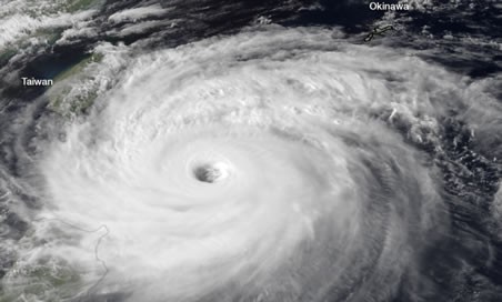
Typhoon Jelawat remains at very strong intensity despite weakening from its previous status as a super typhoon. Earlier this week Jelawat had maximum sustained winds of 220km/h near its centre, which would classify it as a category four hurricane by north american standards. The storm currently has maximum sustained winds of 145km/h (as of Friday afternoon), the equivalent of a category two hurricane.

Satellite image of Jelawat on Thursday morning when it was heading toward Taiwan with 155mph sustained winds

Satellite image of Jelawat on Thursday morning when it was heading toward Taiwan with 155mph sustained winds. (JMA/NOAA) – via Washington Post (see sources)

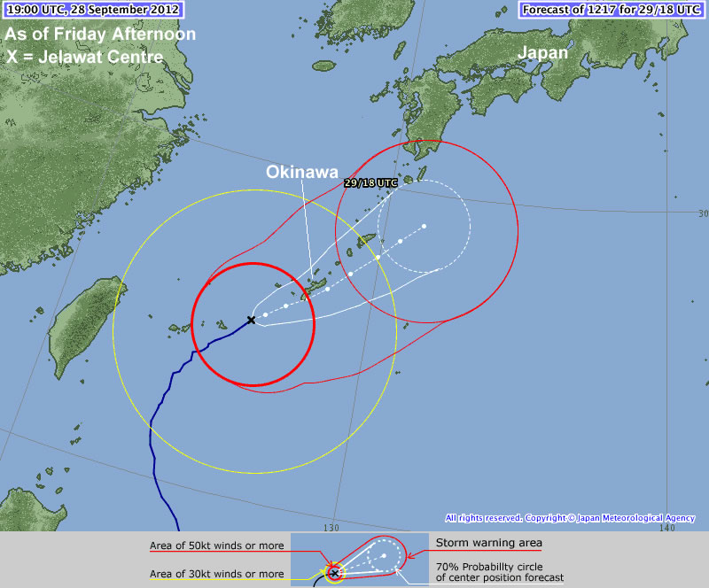
Jelawat is presently located near Okinawa and is moving in a north-easterly direction toward Japan, weakening the further north it moves. According to the Japanese Meterological Agency Jelawat will impact the Ryukyu Islands, including Okinawa, today before moving toward the Japanese mainland late today into Sunday.

Jelawat's Forecast track by the JMA

Jelawat’s Forecast track by the JMA

Thus far Jelawat has not caused any devastating damage, owing to the fact that it has not yet impacted any large land masses. Some damage was reported on Lanyu (Orchid Island), located just off Taiwan’s south-eastern coast. No casualties have been reported on Lanyu, but the harbor, gas station, and supermarket were reportedly destroyed. There may be more damage as this typhoon moves over the more heavily populated Ryukyu Islands this weekend.

Sources: http://www.taipeitimes.com/News/front/archives/2012/09/29/2003543923, http://www.hko.gov.hk/wxinfo/currwx/tc_gis_e.htm, http://www.washingtonpost.com/blogs/capital-weather-gang/post/typhoon-jelawat-closing-in-on-okinawa-japan-nadine-becomes-hurricane-again/2012/09/28/c0f6844c-097b-11e2-a10c-fa5a255a9258_blog.html