Fall Weather

Fall has officially begun and, rather fittingly, fall weather is in store for the next few days.

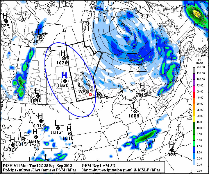
High pressure will be in place over much of Manitoba for the first part of the week

High pressure will be in place over Manitoba for the first part of the week

Temperatures for the first few days of this week are expected to be around or slightly below normal. Monday, Tuesday, and Wednesday will all have high temperatures in the low to mid teens (normal high is 16C). Monday will have a cool north wind, but on Tuesday and Wednesday the wind should not be much of a factor. No notable precipitation is expected for the first half of this week as we remain under a surface ridge of high pressure.

Models have been hinting at some warmer weather towards the end of this week into next weekend. As the high pressure system from earlier in the week moves off to the east it appears that a southerly flow will develop over Southern Manitoba, allowing us to see some more above-normal weather before the end of the month.

Another Blast of Heat

Some more hot weather is in store this week as we close out August. We might even see our hottest day of the summer!

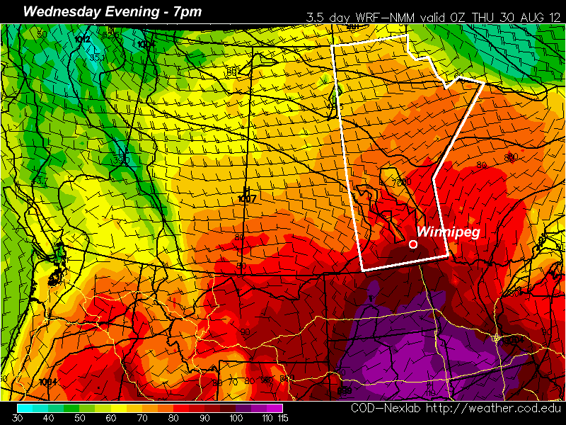
Temperatures in the mid to upper thirties are forecast for parts of Southern Manitoba on Wednesday

The WRF/NAM model is predicting temperatures in the mid to upper thirties in the Red River Valley on Wednesday

Yet another ridge of high pressure will build over the Prairie provinces for this week, bringing more hot weather. Monday will be a nice day, with light winds and high temperatures in the mid to upper twenties in Southern Manitoba. Skies should remain mainly sunny as high pressure suppresses convective cloud cover. By Tuesday temperatures will climb up around the 30C mark, but humidity levels should remain low keeping conditions at least somewhat bearable. Wednesday could potentially be the warmest day so far this summer in many parts of Southern Manitoba. Current models give the following high temperature predictions (for Winnipeg):

  • NAM: 36C
  • ECMWF: 35C (estimated based on 850mb temps)
  • GFS: 32C
  • GEM: 30C

Based on recent model performances, the NAM should be the favoured solution at this point. Given that low humidity is expected on Wednesday, there certainly is the potential for temperatures to reach the mid and upper thirties in Southern Manitoba. The two main factors that will determine how hot it gets are:

  1. How much warm air manages to flow in at the low-levels on Wednesday
  2. Whether or not a moderate-strong low pressure system forms to our west, causing winds to stay southerly or south-easterly on Wednesday

If 850mb temperatures manage to sneak up into the mid twenties over Southern Manitoba on Wednesday and the wind veers to south-westerly or westerly, then expect high temperatures in the mid to upper thirties in most areas. However, if the wind stays more south-easterly on Wednesday with cooler 850mb temperatures, then highs will likely stay stuck around the 30-33C mark. Of course all the above points assume that we will see sunny skies on Wednesday. At this point there doesn’t appear to be anything which would indicate that we will see extensive cloud cover, but that is always a wildcard to consider.

A cold front is expected to pass through at some point on Wednesday night or Thursday, cooling temperatures back down into the twenties for Thursday and Friday.

Chance of Freezing Rain Over The Red River Valley

A large upper trough swinging across the Prairies is supporting two low pressure systems, one in central Saskatchewan and one in the Northern Plains of the United States, that will move across Manitoba overnight and tomorrow morning, bringing with them snow and the risk of freezing rain.

Dec. 31 Prog

For southern Manitoba, the main concern will be the precipitation generated along the apex of the frontal wave as it occludes southeastwards from the northern low in Central Manitoba to Minnesota. The warm front will align somewhere near a line from Winnipeg to Sprague, and slowly shift south/southeast through the day. Areas near the International Border have the greatest risk of freezing rain, due to the higher intensity of the precipitation expected there. The risk diminishes as you head north towards Winnipeg. I agree with the latest Environment Canada forecast that calls for ice pellets in Winnipeg; the warmest air should stay south of the city and we will likely have enough cold air entrenched to freeze any rain that comes out of an above-freezing layer. I can’t exclude the chance of a brief period or two of freezing rain, especially late overnight and early tomorrow morning. As this system develops, snow will become the predominant weather type, and much of the RRV can expect between 2-4 cm of the white stuff, while a few localities may get up to a couple inches.

I think it’s likely areas south of Morris will see some duration of freezing rain before sitching over to snow. The good news is that this doesn’t have the makings for a large-scale freezing-rain event, so there shouldn’t be any concern of widespread highway closures. Given that some roads are already very slippery, however, drivers should take caution when travelling overnight or tomorrow as fresh snow may be hiding a layer of ice underneath. Always drive with care when freezing rain and snow occur.

This system should clear out tomorrow afternoon, bringing in strong northwesterly winds behind it gusting up to 70 km/h. Fortunately, the arctic cold front is well to our north, so while chilly, we likely won’t even seen our temperature drop to even -15 to -20°C for overnight lows before the next swell of warm air pushes across the Prairies, bringing us continued pleasant winter weather with daytime highs in the -5 to 0°C range! The strong winds will move in tomorrow evening and last through much of the day on Sunday before tapering off, bringing us wind chill values as low as -25 in Winnipeg.

So hang in there, a couple chilly days and we’ll be back to pleasant temperatures with a fresh coat of snow! Happy New Year!
Southern Manitoba Under Influence of Record Breaking Low

Southern Manitoba Under Influence of Record Breaking Low