Seasonably Cool Weather Ahead This Week

Temperatures will stay seasonably cool this week in Winnipeg as a couple glancing systems bring chances of light snow.

RPDS 2m Temperature Forecast valid 18Z Thursday April 3, 2025
Seasonal temperatures will build into Winnipeg by Thursday, but a weak cold front will sweep through on Thursday evening.

After a cool start to the morning, breezy southeast winds develop as a warm front pushes north towards southern Manitoba. Temperatures will climb to a high near +2 °C this afternoon with southeast winds of 30–40 km/h gusting up to around 50 km/h. Skies will cloud over through the afternoon; this cloud cover will stick around into the night with a chance of flurries as the warm front moves through. Temperatures will dip down into the -5 to 0 °C range with southeast winds continuing near 20 km/h.

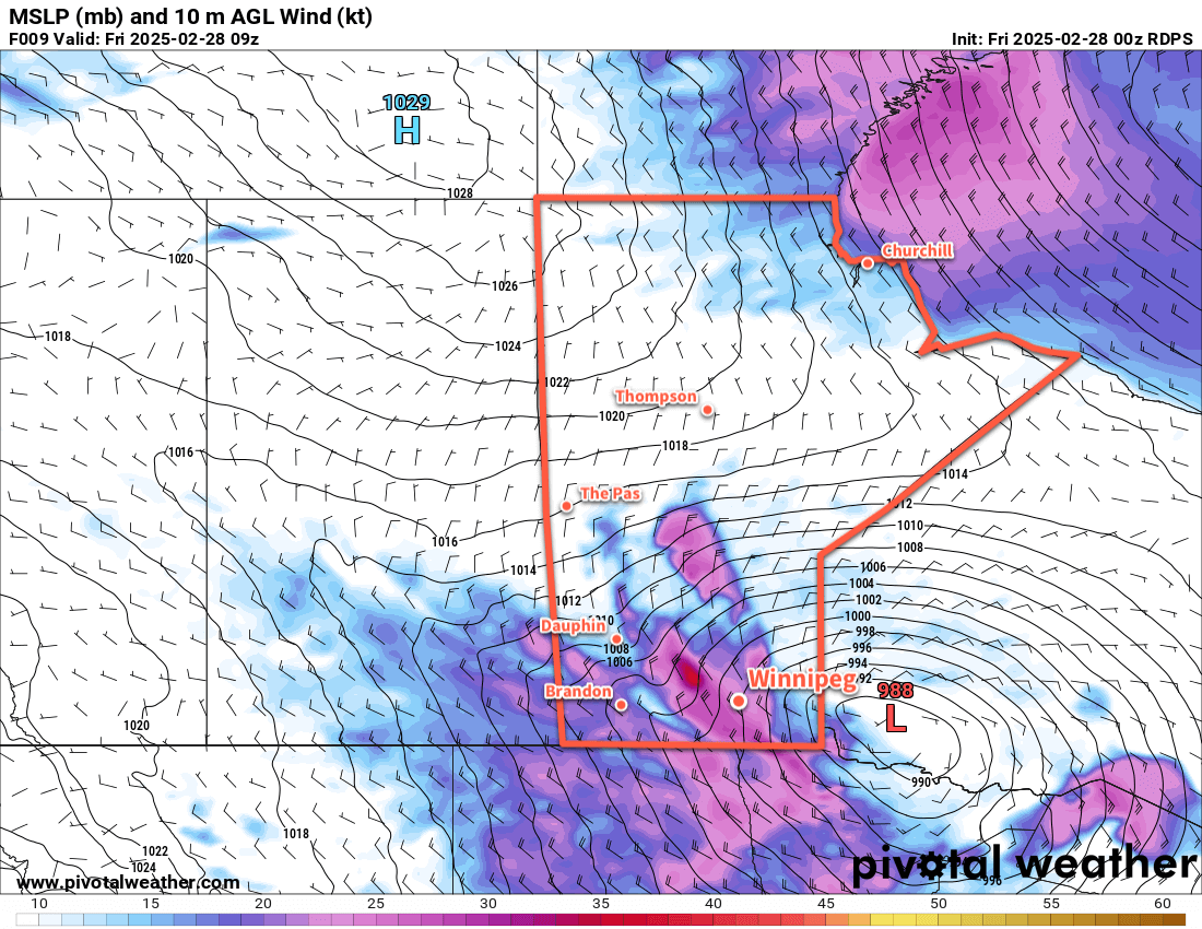
Wednesday will bring cloudy skies to the region as a strong low pressure system moves from the American Plains towards Lake Superior. Temperatures will climb to a high near +3 °C in Winnipeg with easterly winds near 20 km/h swinging around to the northwest through the day. There is a chance of light snow, but it will be contingent on the broader area of snow associated with the low to the south backing northwest all the way through the Red River Valley to Winnipeg. This is an uncertain proposition at this point, and even if the snow does make it this far north, accumulations should be minimal.

Temperatures will dip to the cold side of freezing on Wednesday night with skies staying cloudy.

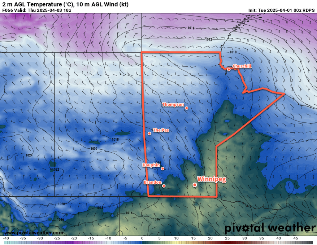
The sun should appear again later Thursday as the low pressure system glancing by the region shifts off into eastern Canada. Temperatures should pop up to around 5 °C in the afternoon with northwest winds of 20–30 km/h. More cloud will move in later Thursday evening, though, as a cold front swings into the area from the northwest. Temperatures will dip into the -5 to 0 °C range on Thursday night with a chance of flurries.

Long Range Outlook

The cloud and chance of flurries will linger into Friday with temperatures gradually climbing back to the warm side of freezing. Clearing skies on Friday night coupled with a cooler air mass will likely send temperatures back down to around -10 °C by Saturday morning.

The weekend will bring variable cloudiness and cool weather to the Winnipeg area. Daytime highs will dip down to freezing by Sunday with chilly overnight lows.

Today’s seasonal daytime high in Winnipeg is 5 °C while the seasonal overnight low is -6 °C.

#awm_snow #awm_windy #awm_below_normal_temperatures

Cold Front Slams Through Southern Manitoba, Brings Brief Cool Snap

A cold front will slam through southern Manitoba this morning and bring strong northerly winds that usher cooler temperatures into the region for a couple days.

RDPS 10m Wind Forecast valid 09Z Friday February 28, 2025
Southern Manitoba will wake up to strong northwest winds behind a cold front today.

A strong cold front has passed through Winnipeg early this morning and has brought strong northerly winds to the area. Widespread winds of 40 to 50 km/h will spread through the Red River Valley this morning, but stronger winds up to 60 gusting 90 km/h will be possible over and in the lee of Lake Manitoba. In particular, strong winds will persist through the morning hours in the corridor roughly between Portage la Prairie and the Elie region.

Blowing snow could be a concern with these winds, but the recent mild weather has glazed the top of the snow pack with ice. There may be flurries with the cold front, but any new snow will be limited. As a result, we don’t expect blowing snow to pose much of an issue this morning.

The winds will ease as the day progresses while temperatures call into the -15 to -10 °C range by the end of the afternoon. The clouds will clear out this evening as temperatures drop to around -20 °C overnight. The wind will ease to light overnight.

The forecast for the weekend is pretty simple. An Arctic high will slump into the province behind the cold front and gradually make its way southeast through the province. Saturday will bring sunny skies and light winds with highs in the -10 to -5 °C range. Temperatures will drop back down into the -15 to -10 °C range on Saturday night with light southerly winds as a warm front begins to push across the region.

On Sunday, much of southern Manitoba will see itself back into the air mass we were in before the cold front came through. Temperatures will rebound back to around 0 °C with southerly winds of 20 to 30 km/h. The warmer weather will likely bring mixed skies to the region.

Temperatures will dip back down into the -5 to 0 °C range on Sunday night with clear skies.

Long Range Outlook

Looking ahead to next week, temperatures will continue trending mild with daytime highs hovering from around or just below 0 °C to as high as the mid-single digits. No significant precipitation is in the forecast.

The mild weather of late has been a pleasant break from a lengthy stretch of cold weather this month; today’s system will bring a brief shot of cooler weather, but the warm-up will arrive before the end of the weekend!

Today’s seasonal daytime high in Winnipeg is -5 °C while the seasonal overnight low is -16 °C.

#Winnipeg #MBstorm #awm_windy #awm_benign

Mild and Slightly Unsettled

Seasonably mild conditions will continue in Winnipeg this week as a couple disturbances track through the region.

RDPS 2m Temperature Forecast valid 21Z Wednesday February 26, 2025
A weak disturbance will cross southern Manitoba on Wednesday afternoon.

Daytime highs in the 0 to +3 °C range will continue through the rest of the work week for the Winnipeg area. Upper ridging over the western Prairies will continue to allow mild Pacific air to push east across the region.

There will be plenty of cloud cover this week, a result of both the disturbances tracking through the region and the extensive snow melt taking place across the region.

Today will bring mainly cloudy skies to the region with southerly winds picking up to around 20 km/h. Temperatures should climb above freezing for the afternoon. A few clear breaks are possible this evening as temperatures head to a low near -3 °C overnight.

A disturbance will drop into southern Manitoba from the northwest through the day Wednesday. Under cloudy skies, temperatures will climb back above freezing, then temperatures will cool in the evening as light precipitation makes its way through the region. This could fall as either rain or snow, it will depend on how close to 0 °C the temperatures are by the time it begins.

The precipitation will change to flurries on Wednesday night and taper off early Thursday. Temperatures will dip to a low in the -10 to -5 °C range on Wednesday night.

Thursday will bring mixed to cloudy skies to the Winnipeg area with a high close to the freezing mark. A more organized disturbance will push a warm front into southern Manitoba on Thursday night, keeping temperatures within a few degrees of the freezing mark through the night. Breezy southerly winds will pick up overnight as the front approaches.

RDPS 2m Temperature Forecast valid 00Z Friday February 28, 2025
A stronger low pressure system will bring a wintery mix of precipitation to southern Manitoba on Friday.

Friday will bring light rain or snow to the region, but much of the precipitation will likely fall north and east of Winnipeg. It could even end up being a drier day in Winnipeg depending on how dry the air being pulled into this system from the south ends up being.

Temperatures will reach a high near 0°C on Friday with westerly winds near 40 gusting 60 km/h. Those winds will shift northwest later in the day as much of the precipitation moves off. This will bring cooler temperatures and a chance of flurries to the region.

The northwest winds will ease overnight as skies clear and temperatures drop into the -20 to -15 °C range behind the departing system.

Long Range Outlook

Looking further ahead, Saturday will bring cooler weather to the region, but temperatures should bounce back towards freezing on Sunday. The city should see sunshine this weekend, but conditions will trend cloudier into next week as the mild air sticks around.

Today’s seasonal daytime high in Winnipeg is -6 °C while the seasonal overnight low is -16 °C.

Weekend Snow Brings Early-February Cold Snap to Southern Manitoba

A low pressure system crossing the Prairies will bring more snow to Winnipeg and area this weekend, but its cold front will usher Arctic air back into the region.

RDPS 2m Temperature Forecast valid 06Z Sunday February 2, 2025
A passing low pressure system will bring light snow and another day of seasonably mild temperatures before Arctic air pushes back into the area.

A cold front slumped through the region yesterday evening, northerly winds and cooler temperatures for the end of the work week. Daytime highs in the Winnipeg area will sit in the -20 to -15 °C range today as north winds of 20 to 30 km/h gradually ease. The seasonably cool weather will at least come with sunny skies.

The weather will turn this evening as a low pressure system building into the Prairies pushes cloud over into the region. The cloud cover will help keep temperatures warmer tonight, with lows staying on the warm side of -20 °C before beginning to warm overnight. A warm front will push into the region overnight, bringing some light snow into the region.

Heading through the weekend, a couple waves of light snow will move through Winnipeg with clouds and flurries between them. Temperatures will warm to a high near -5 °C on Saturday as this system pushes the Arctic front back north of the region , then drop to around -10 °C on Saturday night and hover around that mark on Sunday. The region will see southeast winds up to 30 gusting 50 km/h on Saturday ease to light overnight.

While the system moving through the Prairies this weekend will bring a total of 10 to 20 cm of snow to many areas west and north of Winnipeg, the Red River Valley will likely only see 5 to 10 cm of snow by the time it tapers off later on Sunday.

This system will push the Arctic cold front back south through the region on Sunday, bringing moderate northwest winds and colder temperatures. Skies will begin to clear on Sunday night with temperatures heading back down to -20 °C.

Long Range Outlook

Colder weather will settle into the region next week with daytime highs in the -20 to -15 °C for much of the week. A bit of moderation is possible mid-week as a system crossing the northern United States may spread some cloud and light snow into the region as it passes to the south. Cold weather will likely return for the end of thew eek as well with daytime highs possibly dipping into the -20s.

Today’s seasonal daytime high in Winnipeg is -11 °C while the seasonal overnight low is -22 °C.