Southern Manitoba will see the spring melt continue for a few more days, but cooler conditions are on the way for the weekend.
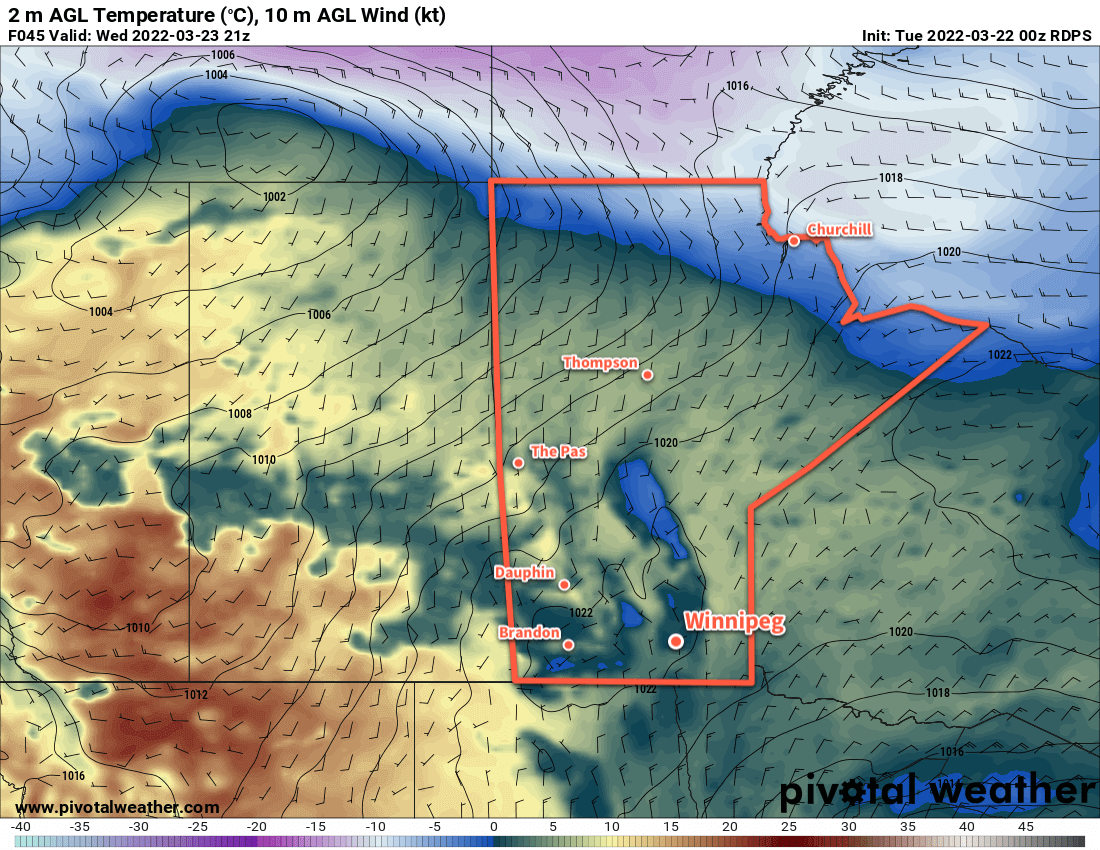
A low pressure system moving through the northern Prairies will bring very mild temperatures to the snow-free portions of the southern Prairies on Wednesday.
Mainly cloudy skies will linger behind the system exiting the region today as the moisture added to the air by the recent rain and melting snow keep things damp. A few sunny breaks will be possible over the next couple days, but organized clearing won’t arrive until Wednesday evening.
The region will see freeze-thaw cycles over the coming days with highs several degrees above freezing and lows below. This will further the — quite honestly, shocking in its rapidity — deterioration of Winnipeg roadways. If you value your tires, avoid those potholes!
Fog patches will also be possible overnight through the next several nights.
Some clearing will move into the region mid-week, but more cloud will arrive later on Thursday as another low pressure system crosses the northern Prairies. Thursday will be the warmest day over the next few with a high climbing above 5 °C, but a cold front will sweep through on Thursday night. It will usher in moderate northwesterly winds along with some more rain showers or flurries Thursday night into early Friday morning.
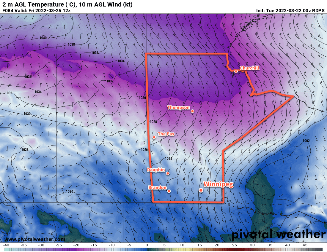
By Friday morning, colder temperatures will return to the province with a moderate northwest wind across Manitoba.
Once that system exits the northern Prairies, a lobe of the Polar Vortex will shift southwards into southern Nunavut. As it does so, cooler air will also push into the Prairies. This won’t result in any sort of deep freeze, but highs will dip down below zero for the weekend.
Long Range Outlook
The spring melt will resume next week as highs climb back up above freezing again. It’s likely that the region will see a lot more cloud as the pattern turns more unstable again, and more rain or snow may be possible in the first half of the week.
Today’s seasonal daytime high in Winnipeg is 1 °C while the seasonal overnight low is -9 °C.
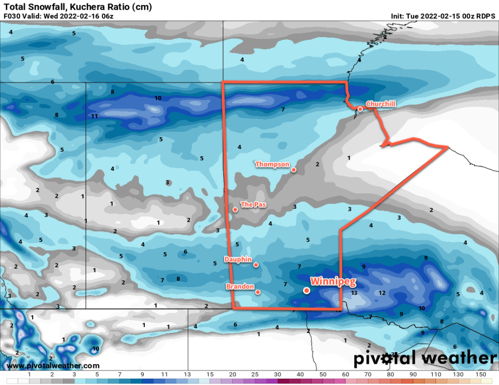
The winter that seemingly never ends continues in southern Manitoba, but more snow may actually mark a shift towards spring-like conditions.
Another low pressure system will bring a swath of 5 cm of snow across Southern Manitoba on Saturday.
Long-suffering Winnipeggers, buried under feet of snow and frozen to the core by a second half of winter largely marked by below seasonal temperatures frequently plummeting below -30 °C, have plenty of reason to look at the forecast with suspicion. Hopes for spring have been dashed several times already this year as long-range warmth is crushed by yet another Arctic High descending from the north.
But…
Major Change is afoot. The polar vortex, anchored near Baffin Island the past while, will soon shunt northeastwards over Greenland. As it leaves, it will take the cold trough responsible for the persistent cold in our region with it. This will allow a moderating westerly flow to develop over the Prairies. As a result, the region should see a return to much closer to seasonal temperatures in the coming week. There’s a good amount of confidence with this larger-scale pattern change, too!
But, before we get that far, there’s the weekend weather to consider. This morning sees the region in the wake of yet another Alberta Clipper, complete with cold conditions, strong northwesterly winds, and another closure of Winnipeg’s Perimeter Highway. These conditions will last into the afternoon before winds begin to ease. The day will bring a few afternoon clouds, but it’ll stay cool with a high in the mid-minus teens. Tonight will be clear and cold with a low near -25 °C.
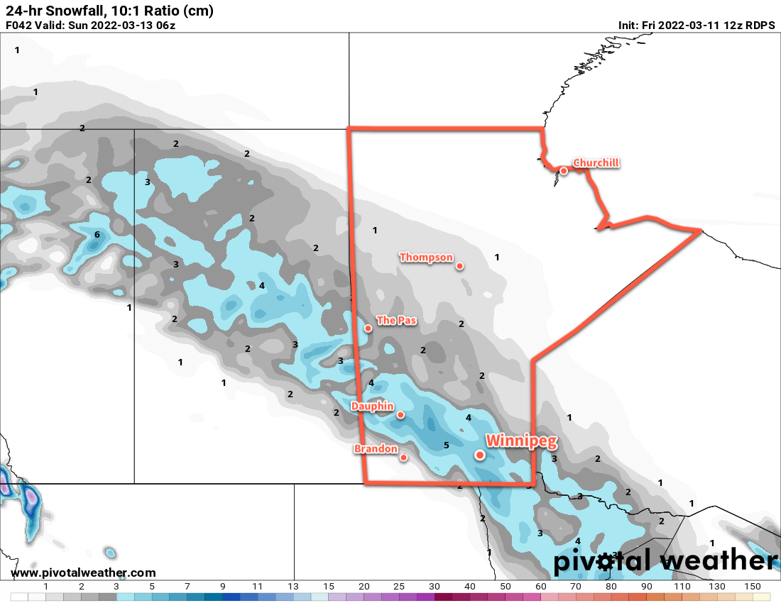
Another low pressure system will begin moving from northern Alberta towards the Manitoba Lakes on Saturday. As its warm front approaches the region in the morning, it will bring increasing cloud as southerly winds strengthen. Blowing snow will develop over the region midday, then conditions will deteriorate mid-afternoon as snow moves into the region. Travel conditions will likely be poor between noon and 9 PM on Saturday. The snow will taper off overnight with 3–5 cm likely through most of the Red River Valley.
This system will, in addition to the wind and snow, bring warmer temperatures into the region. Temperatures will climb to the warm side of -10 °C by Saturday evening. Temperatures will continue to warm into the 0 to -5 °C range through the evening hours. The region will see a low a bit below -10 °C by Sunday morning.
Sunday marks the beginning of daylight savings time, so don’t forget to spring your clocks forward and hour!
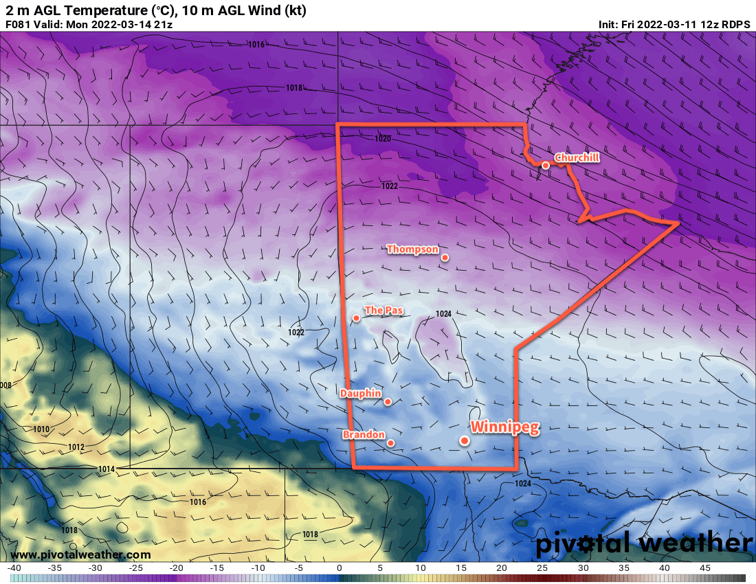
Sunshine returns to the region on Sunday with easing northwest winds and a high in the -5 to -10 °C range. Temperatures will cool to the mid-minus teens on Sunday night with light winds a partly cloudy skies.
Long Range Outlook
Next week will mark the transition towards warmer weather, but how warm it gets will be limited by the immense snowpack over southern Manitoba. Temperatures will climb into the -5 to -10 °C range on Monday, followed by a warm frontal passage on Monday night. This will mark the start of a push of milder Pacific air into the region.
A surge of much warmer, spring-like temperatures will begin building across the Prairies on Monday.
Forecast daytime highs for Tuesday through Saturday all sit above freezing; anywhere from 2 to 4 °C above zero. Those temperatures might be tricky to reach without a strong wind keeping the lower atmosphere well-mixed. More likely, the region will see temperatures up to a couple degrees above 0°C. Temperatures warmer than that will be tied to areas with less snow or more exposed concrete (e.g. downtown Winnipeg may see slightly warmer temperatures).
The warmer temperatures will begin melting the snow pack over the region. With dew point values staying at or below freezing, no unusually rapid melt is expected. The warm air combined with the widespread snowpack should result in quite a bit of cloud cover through the week. More sun is possible if southwest or westerly winds develop, helping mix drier air into the Red River Valley.
While we’ve seen plenty of broken spring promises so far this year, it looks like a near-certainty that southern Manitoba will finally see some relief from the cold begin next week.
Today’s seasonal daytime high in Winnipeg is -2 °C while the seasonal overnight low is -12 °C.
Winnipeg will see cool conditions and more snow as clipper after clipper moves through the region.
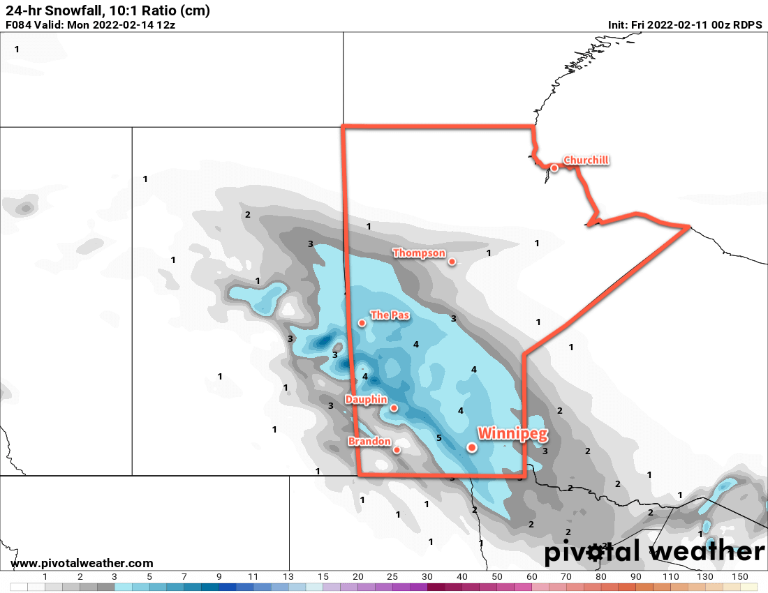
5–10 cm of snow will fall across most of southern Manitoba today.
The snow will gradually pile up this week as multiple disturbances move through southern Manitoba. This train of clippers will keep temperatures generally below seasonal and add to the ever-growing snow banks around the city.
The first clipper will move through the region today, bringing moderate southerly winds, some blowing snow in open areas, and 5–10 cm of new snow by the time it tapers off in the evening. The wind will ease off in the afternoon with a high around -10 °C. Temperatures will head back into the low minus teens tonight with some blowing snow and moderate northwesterlies.
The cloud cover will break up on Wednesday as an Arctic ridge moves into the province. Expect some blowing snow in open areas in the morning, followed by improving conditions as the northwesterlies ease through the afternoon. Temperatures will hover in the -15 to -20 °C range through the day, then quickly drop in the evening with clear skies. Winds will be light on Wednesday night with lows dropping back below -30 °C.
Bitter cold returns to southern Manitoba on Wednesday night with lows bottoming out below -30 °C on Thursday morning.
Thursday will be a sunny, cold day with temperatures topping out in the -20 to -25 °C range. The next clipper to impact the region will start pushing in on Thursday evening, bringing increasing cloud and warming tempreatures. Snow will begin overnight as southerly winds strengthen and temperatures warm into the mid-minus teens. More blowing snow will again develop through the Red River Valley by Friday morning.
Long Range Outlook
Another clipper moving through the region on Friday will bring 5–10 more centimetres of snow to the Red River Valley. There will be little reprieve afterwards, as forecast show yet another low impacting the province on Saturday. This system could end up bringing closer to 10 cm of snow to the region on Saturday into Sunday.
Temperatures will trend on the cooler than seasonal side of things through the weekend and potentially cool a little bit more heading into next week.
Today’s seasonal daytime high in Winnipeg is -8 °C while the seasonal overnight low is -18 °C.
Winnipeg will see temperatures slide back into the “cold” category this weekend as another Arctic ridge settles into the province.
Temperatures will plummet back into the -30s Friday night into Saturday morning.
Today will start out with unpleasant conditions as the region sees blowing snow with moderate northwest winds of 40–50 km/h. The wind will ease through the day with gradual clearing as an Arctic high settles into the region. Temperatures will be notably colder than yesterday with little recovery from the overnight low. Temperatures will hover in the -20 to -25 °C range through the day, then drop below -30 °C tonight under clear skies.
The cold weather will stick around for Saturday, a weak upper trough moving through will likely bring some cloud cover as well. Highs will again sit in the -20 to -25 °C range, and temperatures will head back towards -30 °C tonight.
More snow will move through southern Manitoba on Sunday.
The next low pressure system to impact the region will move through on Sunday. Moderate southerly winds of 40–50 km/h will develop as cloud moves in early in the day, likely producing some areas of blowing snow through the Red River Valley. Snow will move into the region sometime midday, then taper off in the evening.
This system will push the coldest air out of the region, and while it will stay cool into next week, temperatures won’t be as bitterly cold as the region will see this weekend.
Long Range Outlook
Next week will bring varied conditions with some snow possible on Tuesday and towards the end of the week. Otherwise, the region should see sunshine in between with cool highs in the -15 to -20 °C range.
Heading towards next weekend, several forecast show moderating temperatures, with highs returning to seasonal values for the weekend.
Today’s seasonal daytime high in Winnipeg is -9 °C while the seasonal overnight low is -19 °C.