Southern Manitoba Soaking Marks Arrival of Cooler Weather

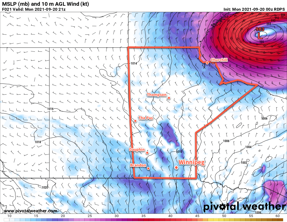
A Colorado Low will bring widespread rain to southern Manitoba today and usher in cooler temperatures for the rest of the week.

Winnipeg will see cloudy skies today with rain beginning midday as it spread northwards out of North Dakota. Rain will move into all of southern Manitoba today and gradually lift northwards through the night. The organized rain should taper off by Thursday morning across much of southern Manitoba.

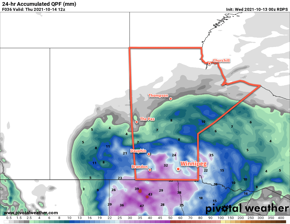
Rainfall totals in Winnipeg will likely sit in the 20–30 mm range with slightly higher amounts to the west along the Red River Valley escarpment. Much of southwestern Manitoba will likely get a good soaking with 25–40 mm possible throughout that region. Rain will also fall to the east of the Red River Valley, but accumulations should be a bit less in the 15–25 mm range.

RDPS 24hr. Accumulated Precipitation Forecast valid 18Z Thursday October 14, 2021
A Colorado Low will bring a proper soaking to southern Manitoba on Wednesday.

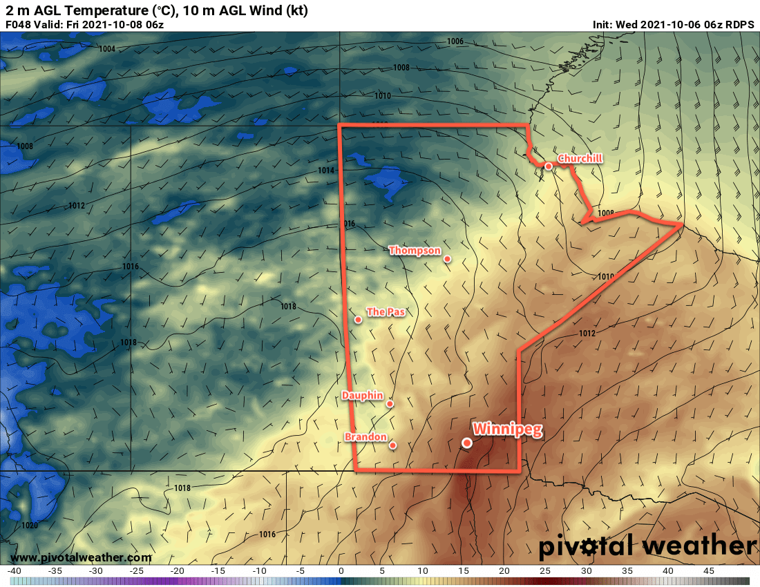
Temperatures will climb to around 10 °C today in Winnipeg with brisk northeast winds strengthening to 40 gusting 60 km/h. Temperatures will keep rising through to around 12 °C overnight as the low centre moves approaches this evening. Once it passes, it will cool back to around 10 °C by Thursday morning. The winds will ease as the low moves through overnight.

On Thursday, Winnipeg and area will continue to see cloudy skies with scattered showers wrapping around the rear flank of the low. With cooler temperatures filtering into the region, some lake-enhanced showers or drizzle will also be possible off the Manitoba Lakes. Temperatures will stay steady around 9 °C with westerly winds up to 30 km/h. Precipitation will taper off Thursday evening, then winds will ease and temperatures will dip to a low near +3 °C.

Friday will bring westerly winds of 20–30 km/h to Winnipeg with temperatures climbing to a high near 9 °C again. Much of the day will bring cloudy skies, but clearing will be working into the Red River Valley through the afternoon and evening hours. Temperatures will be cool on Friday night with a low near 1 °C and light winds under clearing skies.

Long Range Outlook

Temperatures will warm a bit this weekend as a push of mild Pacific spills eastwards across the Prairies. This will set up another low to start off next week that may bring another batch of showers to the region.

Today’s seasonal daytime high in Winnipeg is 11 °C while the seasonal overnight low is 0 °C.

Warmth Continues Until Friday, Then Unsettled

Winnipeg will see another couple days of beautiful warm weather before a large-scale pattern change brings cooler and unsettled weather back to the region.

The upper ridge that brought highs close to the 30 °C mark yesterday will continue to bring seasonably hot conditions for a couple more days. Winnipeg will see breezy southerly winds near 30 gusting 50 km/h over the next couple days as temperatures climb to highs in the upper 20s. Solidly in the warm air, Winnipeg will see another mild low near 16 °C tonight, but temperatures will dip a tad cooler on Thursday night as the warm air begins to move off to the east. The city will see sunny skies today while Thursday will start sunny with cloud moving in through the afternoon.

RDPS 2m Temperature Forecast valid 06Z Friday October 8, 2021
A cold front will push across southern Manitoba on Thursday night.

On Friday, an upper trough moving in from the west coast will push a cold front into southern Manitoba. At the same time, a shortwave will lift out of the Dakotas and will support an area of rain that will move to the northeast. These two things combined will bring cooler, cloudier weather to Winnipeg as winds shift to the north. The city will see a high near 18 °C on Friday with a good chance of rain through the day. The chance for a bit more rain will continue on Friday night as temperatures dip to a low near 12 °C.

Long Range Outlook

Friday marks the beginning of a shift to a much more unsettled pattern that will persist through the weekend and into next week. More rain is likely this weekend with the potential for some more organized accumulations across the region. Conditions will settle with mild temperatures to start next week, then another large storm system is forecast to move in mid-week, bringing the potential for a substantial rainfall and a return to seasonal temperatures.

Today’s seasonal daytime high in Winnipeg is 13 °C while the seasonal overnight low is 2 °C.

Mild Weather Turns Cooler For Week’s End

Breezy southerly winds will usher in another push of seasonably mild temperatures for Winnipeg today. Cooler temperatures lurk just to the north, though, and a sharp cold front will bring much cooler temperatures for Friday.

Moderate southerly winds up to 30 gusting 50 km/h will develop in the Red River Valley today as warmer temperatures push into the region from the west. Winnipeg will see a high near 25 °C with nothing but sunshine through the day. Those southerly winds will keep up through the night at 30–40 km/h and keep lows mild near 13 °C. Skies will stay mainly clear through the night.

Saturday’s main weather feature will be a trough of low pressure moving into the Red River Valley. It will bring partly cloudy skies to the region as the winds shift northwesterly and ease in the afternoon. Temperatures will continue to be warm with a high near 24 °C. Winnipeg will see mixed skies and light northwest winds on Thursday night as a cold front sweeps through. Temperatures will head to a low near 7 °C.

RDPS 2m Temperature Forecast valid 21Z Wednesday September 22, 2021RDPS 2m Temperature Forecast valid 21Z Friday September 24, 2021
A low pressure system will track across the northern Prairies over the next few days, bringing warm weather to the region today that gives way to much cooler weather on Friday.

Breezy northwest winds will flood southern Manitoba with very cool air on Friday. Temperatures will struggle to reach even 15 °C through the day with northwesterlies up to 30 gusting 50 km/h. The cool, unstable air will produce mixed skies over the region, but any rain showers look unlikely. Skies will stay mixed on Friday night as winds ease with a low near 6 °C.

Long Range Outlook

The long-range forecast shows a return to seasonably mild temperatures this weekend that persists through next week. Highs will bounce back into the 20–25 °C range with overnight lows in the 10–15 °C range. This warmer weather will bring variable cloudiness to the region this weekend trending sunnier to start next week.

Also of note, all the forecast models are showing a very dry stretch of weather, with little to no rain possible across the region right through the middle of next week.

Today’s seasonal daytime high in Winnipeg is 16 °C while the seasonal overnight low is 5 °C.

Mild Late-Summer Weather Continues

Seasonably mild conditions will continue in Winnipeg this week, but with breezy winds to go with it.

After a blast of summer heat yesterday, Winnipeg will see a much cooler day today in the wake of a cold front that pushed through the province overnight. The showers associated with that system should come to an end early this morning, leaving behind cloudy skies to start the day. Northwest winds will strengthen this morning to 30 gusting 50 km/h and the cloud should begin to clear out this afternoon. Temperatures will reach a near-seasonal high in the upper teens today, more than 10 °C cooler than yesterday’s warmth. All this adds up to rather unremarkable weather as Winnipeggers head to the polls today.

A ridge of high pressure will move into the province overnight, bringing clearing skies and a low near 6 °C. The northwest winds will gradually ease through the night.

RDPS 10m Wind Forecast valid 21Z Monday September 20, 2021
Breezy northwest winds will spread across most of southern Manitoba for Election Day (Monday).

On Tuesday, Winnipeg will see mainly sunny skies with a high again in the upper teens. The high pressure system over the province should keep the winds light through the day as well. The light winds will shift southerly overnight as temperatures dip to a low near 8 °C.

The city will see more sunshine on Wednesday, but the southerly winds will pick up through the day as warmer air moves back into the region. The day’s high should reach the mid-20s with southerly winds of 30–40 km/h. A few clouds will start building into the region overnight as the next disturbance crossing the Prairies approaches. The breezy conditions will help keep temperatures warmer on Wednesday night with lows near 12 °C.

Long Range Outlook

Mild weather will stick around for Thursday, but then a strong cold front will slump through the region on Friday. Temperatures will fall into the low teens with plenty of cloud and a good chance of showers. The weekend will bring a return of warmer weather.

Today’s seasonal daytime high in Winnipeg is 17 °C while the seasonal overnight low is 5 °C.