Spring Weather Here to Stay

A broad pattern change will bring Winnipeg milder spring conditions through the next week.

While today won’t be quite as beautiful as Tuesday was, the city will enjoy a great start to the day. Under mixed skies temperatures will quickly climb to a high near 15 °C with light winds. Winnipeg will find itself close to a SW–NE frontal boundary that will slide eastwards in the afternoon. By late-afternoon, moderate northerly winds of 30–40 km/h will push cooler temperatures into the region. The frontal passage will bring cloudier skies with a few showers late in the day into the evening hours.

Cooler temperatures will push in overnight with diminishing winds. Skies will clear out with a low near -3 °C.

The cool temperatures won’t stick around, though. On Thursday, temperatures will quickly rebound back to a high near 12 °C. The city will see plenty of sunshine with partly cloudy skies and winds will be light much of the day. Northwest winds will pick up to around 20 km/h this evening as an area of high pressure moves in. Temperatures will dip to a low near -1 °C overnight with clear skies.

RDPS 2m Temperature Forecast valid 21Z Friday April 30, 2021
A warm front will move into Manitoba on Friday, bringing windy conditions to the Red River Valley and much warmer conditions to the southwest corner of the province.

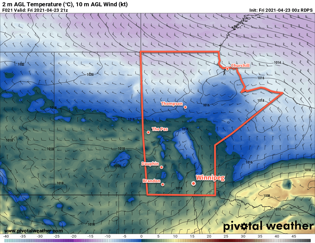
Friday will start off sunny, but an approaching warm front will bring clouds for the afternoon. Temperatures will climb quickly through the morning to a high near 16 °C. Southerly winds ahead of the front will strengthen into the 30–40 km/h range for the afternoon. This warm front will support some rain as it pushes east, but it will stay well north of the Red River Valley. The rain is forecast mainly for central and northern Manitoba and it should stay dry this far south.

The clouds will break up on Friday night with gradually easing winds and a mild low near 6 °C.

Long Range Outlook

Winnipeg’s weekend looks great with plenty of sunshine and highs in the mid- to upper-teens. The seasonal temperatures will continue into the start of next week, but a few disturbances moving through on Tuesday/Wednesday are forecast to bring more cloud and a chance of showers to the region.

Today’s seasonal daytime high in Winnipeg is 15 °C while the seasonal overnight low is 2 °C.

Seasonably Cool Temperatures Ahead

After a cool and windy Friday, temperatures will gradually return towards seasonal values in Winnipeg.

Today will start with moderate northerly winds behind a cold front that moved through overnight. Winnipeg will start off cloudy with north winds near 30 gusting 50 km/h. There will be a chance of flurries early followed by the cloud cover breaking up and clearing through the afternoon. Temperatures will climb to a high near 5 °C. A ridge draped across the region will bring mainly clear skies tonight with a low near -7 °C

The ridge will slide off to the southeast on Saturday, bringing mainly sunny skies to the region. Temperatures will recover a bit with a high near 8 °C and light winds. A few clouds will move in overnight with temperatures falling to a low near -1 °C.

RDPS 2m Temperature Forecast valid 21Z Friday April 23, 2021
The Prairies will see cooler temperatures on Friday in the wake of a cold front that moved through on Thursday.

Sunday will bring increasing cloud to the region as a long-wave upper trough begins to dig over western North America. Temperatures will nudge closer to seasonal values with a high near 11 °C as southerly winds strengthen to around 30 km/h. Skies should be cloudy by the afternoon and will stay so right through the night. A low pressure system moving into the region will bring a chance of rain to the region late overnight, but the main chance for organized rainfall will wait until Monday. Winnipeg will see a low near +2 °C on Sunday night.

Long Range Outlook

The new work week will start with cloudy skies and a chance of rain with a high in the upper single digits. After the low pressure system moves through, the forecast shows variable cloudiness with temperatures warming into the mid- to upper teens.

Today’s seasonal daytime high in Winnipeg is 13 °C while the seasonal overnight low is 1 °C.

Winter Returns to the Red River Valley

Winnipeg will see a blast of April snow as a spring storm stalls over the region.

A slow-moving upper-level vortex will slump into the northern Plains of the United States today and stall over the area. This feature will support a deep and persistent stream of moisture from eastern North America into southern Manitoba for the next couple days. As a result, Winnipeg and region will see waves of snow spread westwards across the region today and tomorrow.

Winnipeg will see snow through the day today with accumulations of 5–10 cm by the evening. Moderate northerly winds near 40 gusting 60 km/h will accompany the snow, but the relatively warm conditions should limit the severity of any blowing snow that may develop. That said, visibilities may deteriorate rapidly at times in pockets of heavier snow. Temperatures will hover around -1 °C through the day.

The snow will continue tonight with winds of 30–40 km/h. Blowing snow might become a bit more of an issue overnight as temperatures drop a bit more to a low near -5 °C. Another 5–10 cm of snow is possible overnight.

Periods of snow will continue on Tuesday with temperatures climbing back to a high near -1 °C. Another 4–8 cm of snow is possible through the day. The snow will taper off Tuesday night, but skies will stay cloudy. The wind will ease into the 20–30 km/h range by Wednesday morning with temperatures dropping to around -5 °C again.

RDPS Total Snowfall Accumulation Forecast (at 10:1 SLR) valid 00Z Monday April 12, 2021 to 06Z Wednesday April 14, 2021
All of southern Manitoba will see a coating of snow from the spring storm affecting the area.

On Wednesday, the whole vortex will push off into eastern Canada, leaving the region with mostly cloudy skies and a chance of flurries. Temperatures will climb back above freezing with a north wind near 20 km/h.

By the time the snow tapers off, this system will have the potential to produce as much as 15–25 cm of snow for the Winnipeg area. The final total, though, will likely end up less than that; a combination of melting early in the event and compaction as it progresses should reduce the total accumulation somewhat. That said, it will likely still be enough to produce poor travel conditions and bring the region a short return to winter.

Long Range Outlook

The sun will return to the region by the end of the week, but seasonably cool conditions will persist. Winnipeg will see highs of 2–5 °C on Thursday and Friday, then climb into the 5–10 °C on the weekend. To start next week, the region will likely see variable cloudiness with near-seasonal temperatures.

Today’s seasonal daytime high in Winnipeg is 9 °C while the seasonal overnight low is -3 °C.

Pleasant Weekend Before A Winter Storm

Winnipeg will see a relatively pleasant weekend after some much-needed rain that fell on Thursday night. Winter isn’t done with the region, though, with a winter storm poised to slam the region by Monday.

A digging trough over western Canada will dominate the upper air pattern over Winnipeg through the coming days. This will bring near-seasonal temperatures and variable cloudiness. Today, the city will see mostly cloudy skies as the system that brought the overnight rain drifts eastwards. A few sunny breaks are likely, though, and should help get the daytime high up to around 10 °C. A brisk north wind will pick up today to around 30 km/h and persist until the evening before tapering off. Skies will clear tonight with a low near -2 °C.

RDPS 2m Temperature Forecast valid Saturday April 10, 2021
Saturday will be a sunny and mild day the Red River Valley.

Saturday will be the nicest day of the next few as a weak ridge moves over the province. Winnipeg will see mainly sunny skies, light winds, and a high near 14 °C. There will be a few clouds overnight with a low near the freezing mark.

On Sunday, the region will begin to fall under the influence of a low pressure system moving southeast from Saskatchewan. Winnipeg will see increasing cloud through the day with a northeast wind picking up into the 20–30 km/h range. Temperatures will climb to a high near 10 °C.

Long Range Outlook

A major winter storm will move through Manitoba Sunday night through Tuesday, bringing significant snowfall to the region. Precipitation will spread through the province on Sunday night, and while some areas may see a bit of rain to begin, everything should change to snow by Monday morning. There is still significant disagreement in the forecasts where the heaviest snow will fall, but there is good agreement with some regions seeing up to 15–25 cm of snow. Unfortunately for Winnipeg, the range in forecast solutions is huge right now…from ≤5 cm of snow to over 20 cm. So at this point it’s a matter of waiting and seeing how this begins to shape up closer to the event.

RDPS Precipitation Type and Rate Forecast valid 12Z Monday April 12, 2021
Snow is forecast across most of southern Manitoba by Monday morning.

That said, it will likely impact most of southern Manitoba and provide much-needed moisture to alleviate some of the drought conditions. In the wake of this system, a slow return towards highs around 10 °C by the weekend is forecast with plenty of cloud cover, allowing the snow melt to gradually soak into the ground.

Today’s seasonal daytime high in Winnipeg is 9 °C while the seasonal overnight low is -3 °C.