Mild Weather Continues

Winnipeg will continue to see seasonably mild and windy weather this weekend.

Temperatures will climb into the mid-teens quickly this morning, but a cold front passing midday will cap the high near 16 °C. Behind the front, breezy northwest winds up to 40 gusting 60 km/h will develop for the afternoon hours. Although the front will bring some clouds to the region, there will be plenty of sun through most of the day.

The winds will taper off this evening as a ridge of high pressure builds in from the north. Winnipeg should see a low near +1 °C with partly cloudy skies.

Temperatures will be a bit cooler on Saturday as the ridge leaves the region. Winnipeg will see mostly sunny skies with a near-seasonal high around 13 °C. Winds will pick up out of the south in the afternoon to 30 gusting 50 km/h and then increase to 40 gusting 60 km/h overnight. These southerly winds will bring a surge of warm air northwards and the city will see a mild overnight low 10 °C.

RDPS 2m Temperature Forecast valid 21Z Sunday October 11, 2020
The Red River Valley will see mild temperatures with daytime highs climbing into the low 20s on Sunday.

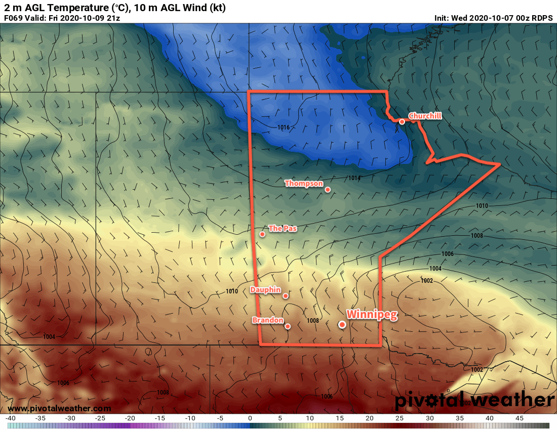
A low pressure system passing through on Sunday will bring mostly cloudy skies to the region for the day. Winds will continue out of the south at 30 to 40 km/h, continuing to tap into warmer air. This will send high temperatures to around 20 °C. There will be a little bit of instability in the region through the afternoon hours that may result in a few showers or thunderstorms. The chance is low in the Red River Valley and much more likely that the southeastern corner of the province.

Winds will shift to the southwest and ease to 20 km/h on Sunday night with mixed skies. Temperatures will still stay seasonably mild with a low near 8 °C.

Long Range Outlook

Temperatures will shift back towards seasonal values through the first half of next week. Many forecasts show cooler weather moving in for the second half of the week with daytime highs dipping into the 5–10 °C range. Dry weather is forecast to continue through much of the week.

Today’s seasonal daytime high in Winnipeg is 12 °C while the seasonal overnight low is 1 °C.

Warm, Dry Weather Ahead

Winnipeg will continue to see seasonably mild temperatures through the rest of the week along with plenty of sunshine.

If there’s a thing that can be said for Winnipeg in 2020 — considered by many to be a bit of a tire fire of a year — is that spring and summer have generally brought pleasant weather to spend time outside. And that seasonally pleasant outside weather continues after the brief cool snap last week!

Upper ridging will gradually spread across the Prairies through the rest of the week, bringing partly cloudy to mixed skies and highs of 15–20 °C. The subsidence associated with the upper ridge will also keep things nice and dry over southern Manitoba.

Lows will dip close to freezing tonight and the low single digits on Friday night. A weak low moving through the region on Thursday night will help keep temperatures warmer with a low near 8 or 9 °C.

RDPS 2m Temperature Forecast valid 21Z Friday October 9, 2020
Seasonably warm weather will return to Winnipeg on Friday.

If there’s any downside to things, it’s that it will be a bit breezy over the coming days. The city will see northwest winds up to 30 gusting 50 km/h today that ease this evening. On Thursday, a southerly flow will strengthen ahead of an approaching low into the 30–40 km/h range. Winds will ease Thursday night. On Friday, northwest winds of 30 gusting 50 km/h will redevelop behind the departing low.

Long Range Outlook

Temperatures will briefly dip to seasonal values on Saturday as an Arctic high glances through the region. On Sunday, warmer temperatures will quickly build back into southern Manitoba with highs near 20 °C possible. Clouds will spread in through the day with showers possible to start the work week on Monday.

Temperatures are then forecast to shift seasonably cool for the rest of the work week with conditions staying on the cloudier side.

Today’s seasonal daytime high in Winnipeg is 13 °C while the seasonal overnight low is 2 °C.

Mild And Unsettled Conditions Ahead

Out of the grip of Arctic air, Winnipeg will see seasonably mild conditions to start the week. With the warmth will come some unsettled conditions that may bring a couple rounds of showers to the city.

Winnipeg will see a cloudy start to the day ahead of a weak “cool” front that will push through midday. The front will bring a few showers to the region as it moves through, followed by some afternoon clearing. Temperatures should pop up to a high near 18 °C in the afternoon with winds picking up out of the northwest to 30 gusting 50 km/h.

Skies will stay clear only briefly in the evening with more spreading into the region overnight ahead of the next disturbance. Temperatures will dip to a low near 9 °C with winds easing.

RDPS 12hr. Accumulated Precipitation Forecast valid 21Z Monday October 5, 2020
A band of showers will spread across southern Manitoba through the day on Monday.

On Tuesday, a low pressure system passing through the Interlake will bring mild temperatures back to the region again. Winnipeg will see a high near 18 °C with mixed skies. Winds will be light for the morning, but northwest winds near 30 gusting 50 km/h will redevelop as cooler air pushes in again through the afternoon. The city will likely see some showers move through later in the day.

Skies will clear out on Tuesday night with easing winds and a low near 7 °C.

Seasonal temperatures will move into the region for Wednesday with a high near 14 °C in Winnipeg. The city will see mainly sunny skies with light northwest winds. A bit of cloud will build back into the region on Wednesday night with a low near +3 °C.

Long Range Outlook

Winnipeg should see near-seasonal temperatures right into the weekend with variable cloudiness. The next notable chance for rain is forecast for the start of next week, so enjoy the pleasant early October weather!

Today’s seasonal daytime high in Winnipeg is 14 °C while the seasonal overnight low is 2 °C.

Cooler Conditions Ahead

A cold front plowing southwards today will usher significantly cooler fall conditions into southern Manitoba.

Winnipeg will see moderate northerly winds today that usher in a seasonably cool air mass that will stick around into the weekend. Under cloudy skies, Winnipeg will see winds strengthen to 40 gusting 60 km/h today in the wake of a cold front that moved through last night. The city will see a chance of showers in the morning, but a more organized area of light rain will move through with another cold front in the afternoon. Temperatures will reach a high of near 11 °C. The wind will persist out of the north through the night near 30 km/h with a low near +2 °C.

RDPS 12hr. Precipitation Accumulation Forecast valid 06Z Thursday October 1, 2020
Showers will spread through southern Manitoba on Wednesday afternoon and evening.

Thursday will bring skies on the cloudier side to the city with temperatures struggling to recover much. That northerly wind will gradually ease through the wind with a high near 8 °C. A few showers will be possible in the lee of the lakes. A high will move through on Thursday night, bringing light winds, partly cloudy skies, and lows dipping just below freezing.

On Friday, a low pressure system will slide southeast through Saskatchewan into the Dakotas. As it moves through, it will spread more cloud over southern Manitoba along with light southerly winds. Temperatures will be seasonably cool again with a high near 9 °C with more showers possible in the evening and overnight as a trough moves across the region. Temperatures will dip to a low near +2 °C on Friday night.

Long Range Outlook

Cool weather will persist into Saturday with some lingering lake-effect precipitation into the afternoon hours. A bit of clearing is forecast to move in on Saturday night, but more cloud returns Sunday as a warm front pushes across the province. This will bring warmer weather back to the region with highs in the mid-teens by Monday. This seasonably warm weather should stick around for much of next week.

Today’s seasonal daytime high in Winnipeg is 15 °C while the seasonal overnight low is 3 °C.