More Rain on the Way

A clipper system will begin racing eastwards across the Prairies today, spreading rain into the Red River Valley.

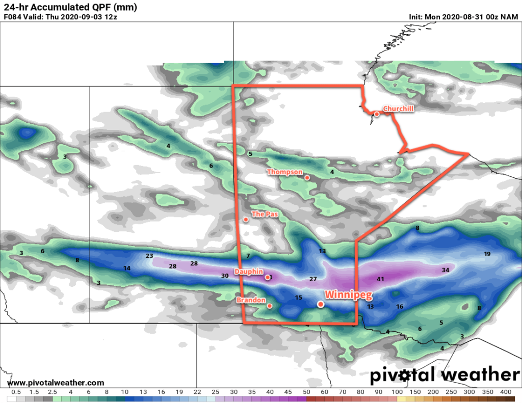
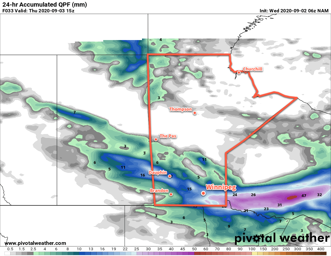
Winnipeg will see a pleasant start to the day; with sunny skies temperatures will climb to a high near 21 °C with westerly winds near 20 km/h. Later today, a clipper low racing across Saskatchewan will spread cloud into the Red River Valley, followed by rain beginning mid- to late-afternoon. The rain will last into the evening, then ease to a few showers and end overnight. Most areas in the Red River Valley, including Winnipeg, will see 5 to 15 mm of rain, but a localized corridor of 15 to 25 mm will be possible. Temperatures will dip down to a low near 10 °C tonight with winds picking up out of the northwest.

Thursday will bring mixed skies with a chance for some lake-effect showers in the morning. Winds will be prominent through the day, sustained out of the northwest up to 40 gusting 60 km/h. It will be a cool day in the wake of Wednesday’s clipper and Winnipeg will see a high of only 17 °C. Skies will clear out in the evening as the winds gradually ease. Temperatures will then head to a low near 6 °C.

NAM 24hr. Precipitation Accumulation Forecast valid 15Z Thursday September 3, 2020
Southern Manitoba will see another soaking as rain moves through on Wednesday afternoon and evening.

On Friday, a weak ridge of high pressure will keep skies mainly sunny with northwest winds of 20–30 km/h. Temperatures will recover slightly from Thursday as Winnipeg heads to a high near 20 °C. A bit of cloud will work into the region overnight as temperatures head to a low near 7 °C and winds ease.

Long Range Outlook

Another low pressure system will cross Manitoba this weekend, but most forecasts show the rain it will bring tracking through WestMan and the Interlake. Winnipeg will likely see mixed skies on Saturday with near-seasonal temperatures, but cloudier, cooler conditions return on Sunday. The weekend may end with a chance of showers as a cold front plunges southwards through the province.

Today’s seasonal daytime high in Winnipeg is 21 °C while the seasonal overnight low is 8 °C.

Cooler, Cloudier, and Windier Weather Ahead

Seasonably cool temperatures have arrived in Winnipeg and will stick around for the week. Alongside them, the city will see increasingly unsettled and windy coconditions.

The city will start the week with a sunny and breezy day in the wake of yesterday’s rain. Temperatures will climb to a cool high near 19 °C with breezy westerly winds of 30 gusting 50 km/h. A ridge of high pressure moving through overnight will keep skies clear but send temperatures plummeting. Winds will taper off the in the evening, then temperatures will head to a low near 6 °C in Winnipeg.

On Tuesday, a trough will swing across southern Manitoba, bringing seasonal temperatures back to the region. It will also bring plenty of cloud cover. Skies will be mostly cloudy in Winnipeg with a high near 22 °C and west-southwest winds into the 30–40 km/h range. The city will see a chance of showers in the afternoon and evening, but rain is more likely across the Interlake into the southeast corner of the province. Temperatures will dip to a low near 9 °C on Tuesday night with clearing skies and easing winds.

NAM 24hr. Precipitation Accumulation Forecast valid 12Z Thursday September 3, 2020
Rain will spread across southern Manitoba on Friday into Friday night.

On Wednesday, a low pressure system will move across southern Manitoba. As it pushes east, it will spread cloud into the region as it lifts a sharp warm front north of the border. Winnipeg should see a high near 22 °C again with some rain beginning later in the afternoon. The rain will continue into the evening and then taper off overnight. This system will bring 20 to 30 mm along a narrow west-east axis that is forecast to run across the Interlake. To it south, 5 to 10 mm is possible across the Red River Valley. That said, the outcome will be sensitive to the track of the low:

  • If the low tracks further north, Winnipeg may see slightly warmer temperatures and less rain.
  • If the low tracks further south, temperatures would be a couple degrees colder than forecast, and rainfall accumulations could significantly increase.

Temperatures will dip to a low near 7°C on Wednesday night with winds picking up out of the northwest to 30 gusting 50 km/h.

Long Range Outlook

Seasonably cool temperatures will move into Winnipeg for the later half of the week with mostly sunny skies. Looking to the weekend, Winnipeg will see variable cloudiness with temperatures continuing on the cooler side of seasonal.

Today’s seasonal daytime high in Winnipeg is 22°C while the seasonal overnight low is 9°C.

A Return to Seasonal Temperatures

A large-scale pattern change will bring an end to the prolonged summer heat alongside cloudier conditions.

Winnipeg will see a cloudy start to the day with northwest winds around 20 km/h. After a cloudy morning, the sun should make an appearance for the afternoon, helping it warm up to a high near 25 °C. Winds will diminish tonight as an area of high pressure builds across the province. The city should see a low near 11 °C under clear skies.

On Thursday, Winnipeg will enjoy a sunny start to the day, but an approaching low will begin to spread cloud into the region in the afternoon. Temperatures will reach a seasonal high near 24 °C. On Thursday night, the Saskatchewan low will push into Manitoba. Its arrival will keep skies mostly cloudy through the night and bring rain through WestMan and the Interlake. For Winnipeg and the RRV, it will bring a chance of showers after midnight. Temperatures will dip to a low near 15 °C.

RDPS 12hr. Precipitation Accumulation Forecast valid 12Z Friday August 28, 2020
A low pressure system crossing the province on Friday night will bring rain across the Interlake and showers to southern Manitoba.

On Friday, a few showers are likely in the morning as a cold front pushes through the region. In its wake, northwest winds will strengthen to 30 gusting 50 km/h as skies clear. It will mark a return to seasonal temperatures in Winnipeg with a high near 22°C. Temperatures will dip to a low near 11 °C on Friday night with the winds easing off.

Long Range Outlook

The weekend will bring a mixed bag to the region with near seasonal temperatures. Winnipeg will see highs in the low to mid-20s both days with overnight lows of 10–15 °C. Saturday should bring mainly sunny skies to the region, but another low moving through on Sunday may bring rain and/or thunderstorms to the region into Monday. Next week will bring variable cloudiness and highs near 20 °C.

Today’s seasonal daytime high in Winnipeg is 23 °C while the seasonal overnight low is 10 °C.

Cooler With Showers Likely

Winnipeg will see cooler conditions as unsettled weather continues over the next couple days.

Cool and cloudy conditions will continue in Winnipeg today. A low pressure system lifting northeastwards out of the Dakotas will spread cloud and showers across the Red River Valley through the day. Many areas in the Red River Valley will likely see showers through the day today with accumulations of 10 to 20 mm. Areas of more intense convection with isolated thunderstorms may develop with this system as well, producing localized rainfall accumulations in excess of 30 mm.

The cloudy, wet conditions will keep temperatures cool with a high near 20°C. It will also be a windy afternoon with northwest winds strengthening to 30–40 km/h. Winds will taper off this evening with temperatures dipping to a low near 11°C.

NAM Simulated RADAR Reflectivity valid 00Z Saturday August 8, 2020
A low pressure system lifting northeastwards will spread showers through southern Manitoba today.

Saturday will bring mixed skies to the region with west-northwest winds of 20–30 km/h. An upper trough moving through the region will bring a chance of showers to the area again through the afternoon, but the increased sunshine will help temperatures climb to a seasonal 25°C. Skies will clear out in the evening with easing winds as temperatures head to around 12°C.

Settled conditions will push into the Red River Valley for Sunday as an upper ridge builds across the Prairies. Winnipeg will see a few clouds through the day and temperatures will reach a seasonably cool high near 22°C. Winds will be breezy out of the northwest up to 30 gusting 50 km/h through the day. As a high pressure system moves into the region on Sunday night, any remaining cloud will clear out, the winds will ease, and temperatures will head to a low near 11°C once again.

Long Range Outlook

Next week is looking great for Winnipeg with more pleasant summer conditions. The city should see plenty of sunshine through the week with near-seasonal temperatures. There may be some chances for thunderstorms with disturbances rippling southeastwards down the upper ridge, but much of that activity would likely be focused more during the nighttime hours.

Today’s seasonal daytime high in Winnipeg is 25°C while the seasonal overnight low is 12°C.