Pleasant Days Ahead With Increasingly Unsettled Nights

Winnipeg will see temperatures begin to climb again as a deep southerly flow begins pushing summer heat back towards the region. With it, though, will come increasingly unsettled overnight conditions.

Today will be a cool but pleasant day in Winnipeg. With partly cloudy skies and breezy northwest winds near 30 gusting 50 km/h, temperatures will climb to a high near 19°C. A ridge of high pressure sliding across the province will ensure the winds drop off quickly in the evening. Temperatures will dip to a low near 8°C.

On Saturday, seasonal temperatures will return to Winnipeg with highs climbing to around 22°C. Southeasterly winds will begin to pick up in the afternoon into the 20 to 30 km/h range. Skies should be mainly sunny as well, making for a great summer Saturday. Conditions will turn heading into the evening, though, as clouds move in ahead of a warm front approaching the region. Overnight, a strong low-level jet will develop, supporting a broad area of showers that will lift northwards through the night. The showers will have limited instability, so while isolated thunderstorms will be possible there won’t be a notable severe weather threat. The showers will exit the region late overnight or early Sunday morning. The southeasterlies will persist right though the night at 30 to 40 km/h and temperatures should dip to a low near 13°C.

NAM Simulated RADAR Reflectivity valid 09Z Sunday June 7, 2020
Showers will move through southern Manitoba on Saturday night.

Sunday will bring mostly cloudy skies to the region with winds gradually easing to 30 gusting 50 km/h. After Saturday night’s showers move out, the day should stay dry. The high temperature will be a bit tricky and highly dependent on how much sunshine the city ends up with. A rather warm and humid summer air mass will be moving into the region. If skies stay overcast, Winnipeg may see a high of only 23 or 24°C. If the sun manages to poke out a bit more, temperatures could reach as high as the upper 20’s. For now, we expect a few sunny breaks but otherwise mainly cloudy skies and a high near 26°C.

NAM 2m Dew Point Forecast valid 00Z Monday June 8, 2020
Humid conditions will move into Southern Manitoba on Sunday afternoon with dew points climbing into the upper teens.

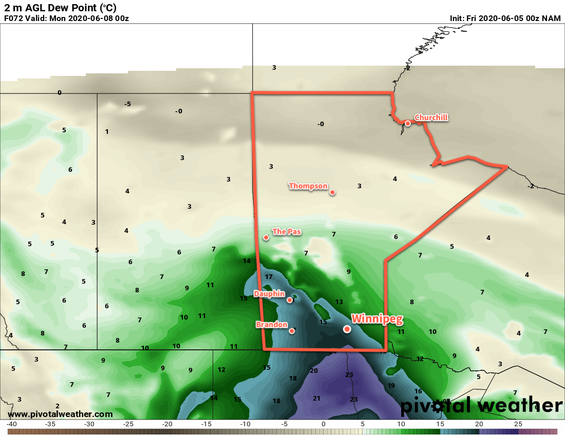
It will be a warm night on Sunday night with a good chance of showers and thunderstorms. The region may see isolated to scattered severe thunderstorms on Sunday night; be sure to check ECCC’s thunderstorm outlook as the weekend progresses in our Bulletin Viewer. Temperatures will reach a low near 18°C on Sunday night with relatively humid conditions.

Long Range Outlook

To start next week, Monday will bring more hot and humid weather with high approaching 30°C and humidex values near 35. Drier westerly winds will move into the region by Monday evening, breaking the humid weather and allowing lows to return to the mid- to low teens. The rest of the work week looks to bring seasonal to slightly cool temperatures and variable cloudiness.

Today’s seasonal daytime high in Winnipeg is 22°C while the seasonal overnight low is 9°C.

Cold Front Brings Windy, Cool Weather

A cold front moving through southern Manitoba today will usher in windy and cooler conditions for the rest of the work week.

Today will be a comparatively pleasant day in Winnipeg with plenty of sunshine. Temperatures should reach a high near 24°C with gusty winds picking up out of the west into the 30 to 40 km/h range. The winds will ease up tonight as temperatures head to a low near 11°C under mainly clear skies.

GDPS 850mb Temperature Anomaly Forecast valid 00Z Friday May 29, 2020
The forecasted 850mb temperature departures from seasonal values show the cooler air mass moving into the province for the end of the week.

For Thursday and Friday, an upper trough moving across southern Manitoba will usher in much cooler weather. Skies will cloud over with a slight chance of showers on Thursday morning, leaving the city with mostly cloudy skies until Saturday. Northwest winds of 30 gusting 50 km/h will usher in much cooler temperatures, limiting Winnipeg’s high to the lower teens both Thursday and Friday. The winds will ease on Thursday night, then return into the 20 to 30 km/h range on Friday. Overnight lows both Thursday and Friday nights will be near 5°C.

Long Range Outlook

Temperatures will return to seasonal values through the weekend with plenty of sunshine. Warmer air will push into the province Sunday night, bringing with it the potential for some unsettled conditions. Heading into next week, hot weather returns to Winnipeg with highs in the upper 20s and overnight lows in the mid-teens.

Today’s seasonal daytime high in Winnipeg is 22°C while the seasonal overnight low is 8°C.

Seasonal Weather Returns to Winnipeg

Winnipeg will see seasonal conditions over the coming days with increasing sunshine.

After a mostly cloudy start to the day, the cloud cover should begin to break up this morning. With mixed skies through the rest of the day, Winnipeg will see temperatures climb to a high near 23°C. Winds will be light out of the north today as a ridge of high pressure moves towards the area. Skies will stay mixed to cloudy tonight as a low pressure system in Minnesota lifts towards Lake of the Woods. It will spread showers across southeastern Manitoba through the night. The rain should stay to the south and east of Winnipeg, but there is a chance that a few passing showers graze the city overnight. Temperatures will dip to a low near 12°C.

NAM 12-hour Accumulated Precipitation Forecast valid 18Z Tuesday May 26, 2020
Showers will clip through southeastern Manitoba on Monday night.

Skies will clear out on Tuesday with a high near 25°C. Winds will shift to the south to around 20 km/h in the afternoon as a low pressure system approaches through Saskatchewan. The city will see mixed skies on Tuesday night with a slight chance of a shower as a cold front swings through. Temperatures will dip to a low near 14°C.

On Wednesday, skies will clear quickly behind the cold front with westerly winds picking up into the 30 to 40 km/h range. The city will see a high near 23°C. Winds will ease to around 20 km/h on Wednesday night as temperatures dip to a low near 10°C.

Long Range Outlook

Cooler temperatures will move in for the second half of the week with highs in the mid-teens and lows down to the mid-single digits. No notable precipitation is in the forecast for the rest of the work week. Heading into the weekend, warmer weather will begin to push back into the region with highs approaching 30°C to start next week!

Today’s seasonal daytime high in Winnipeg is 22°C while the seasonal overnight low is 8°C.

Breezy Conditions Usher in Summer Heat

Winnipeg will rapidly switch to full summer mode as breezy southerly winds usher in markedly warmer temperatures.

What a difference a week makes! Just last Monday temperatures were as low as -10°C with highs struggling to reach a well below-seasonal 8°C. Now, temperatures will continue to climb as summer settles into the region. A slow-moving low over the western Prairies will support a southerly flow over Manitoba through the coming week, pumping heat northwards out of the American Plains.

RDPS 2m Temperature Forecast valid 21Z Tuesday May 19, 2020
Summer heat will spread across southern Saskatchewan and Manitoba this week.

Winnipeg will see daytime highs in the mid-20s over the next few days while overnight lows slowly climb into the upper teens. Alongside the warmer weather, a persistent southerly wind will be in place over the region. Winds will generally strengthen into the 30 to 40 km/h range through the day, the ease into the 20 to 30 km/h range at night. The humidity will also climb over the coming days with dew points climbing into the low teens by Wednesday.

The city will also see plenty of sun over the next few days. Skies will be partly cloudy today with a bit more cloud in the morning than the afternoon. Skies should stay mainly sunny on Tuesday, then a bit more cloud moves in for Wednesday with mixed skies.

Long Range Outlook

The warm weather will continue through the rest of the week, but with increasingly unsettled conditions. By Friday, the region will likely see the chance for scattered showers or thunderstorms. A cold front is forecast to push through late Saturday, bringing near-seasonal temperatures back to the region for Sunday with another chance of showers.

Today’s seasonal daytime high in Winnipeg is 20°C while the seasonal overnight low is 6°C.