Seasonal Temperatures on Friday Give Way to a Warm Weekend

Winnipeg will end the work week with near-seasonal temperatures, but more warmth is on the way for the weekend.

RDPS 2m Temperature Forecast valid 21Z Saturday February 24, 2024
A low pressure system crossing the southern Arctic into Hudson Bay will drag another wave of mild air into southern Manitoba this weekend.

An Arctic high slumping through southern Manitoba will bring near-seasonal temperatures to the region with daytime highs comfortably in the -10 to -5 °C range. Skies will be sunny with light winds that begin to pick up out of the south in the evening.

A strong low pressure system will begin tracking eastwards through the southern Arctic today, and by tonight it will start dragging a warm front across southern Manitoba. Temperatures will dip to a low near -10 °C tonight, then climb into the -5 to 0 °C range by Saturday morning as the warm air pushes into the Red River Valley.

Saturday will bring partly cloudy skies to the region with highs jumping up into the mid-single digits. Breezy southerly winds will shift westerly through the day, hovering in the 20 to 30 km/h range. A weak cold front will slump through the region on Saturday evening. Temperatures will dip to a low in the -10 to -5 °C range overnight.

A ridge of high pressure will cross the region on Sunday, bringing light winds and a high near freezing. Skies will again be partly cloudy but otherwise there will be little weather to talk about to end the weekend.

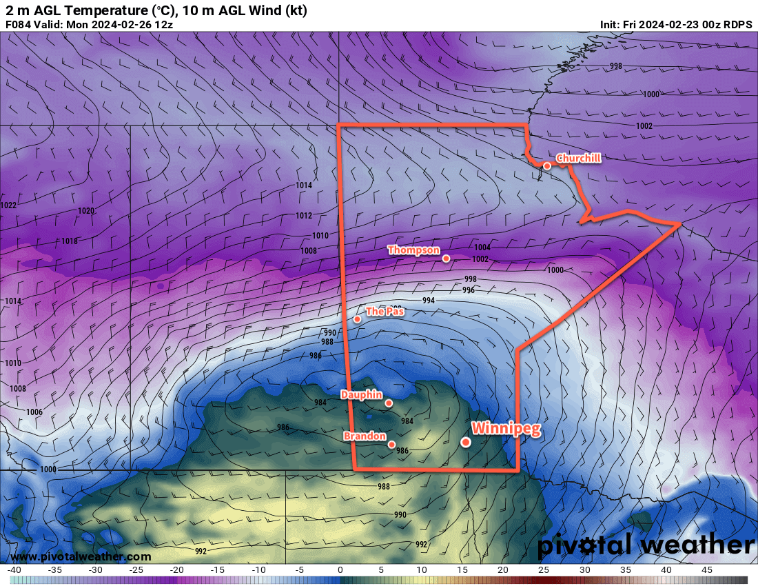
On Sunday night, a potent Alberta Clipper is forecast to begin ejecting eastwards across the Prairies; it will bring much warmer air surging northwards into the Prairies ahead of it as it tracks towards Manitoba overnight. This warmer air pushing into the region will keep overnight lows mild in the -5 to 0 °C range with cloud building in as moderate southeast winds pick up.

Long Range Outlook

Monday’s weather in Winnipeg will be dependent on the exact track of the Alberta clipper. If it tracks more southerly, then the city will see cloudy skies and likely morning snow as the warm front slides through and evening snow as the system’s cold front slams through. In this case, a daytime high near 5 °C wouldn’t be unreasonable.

If, against the odds, the system tracks more northerly, then Winnipeg may escape the morning snow and see temperatures soar into the upper single digits as southwest winds mix mild Pacific air to the surface. Either way, a potent cold front will slam through in the evening and bring strong northwest winds and plummeting temperatures.

RDPS 2m Temperature Forecast valid 12Z Monday February 26, 2024
A potent Alberta Clipper will cross the Prairies on Monday, bringing more mild weather to the south while bitterly cold temperatures push into the north.

A huge Arctic high will slump into the region behind the clipper, sending temperatures plummeting rapidly. Temperatures will likely drop into the -20 to -15 °C range on Monday night, barely recover on Tuesday, and then drop into the mid-minus 20s on Tuesday night.

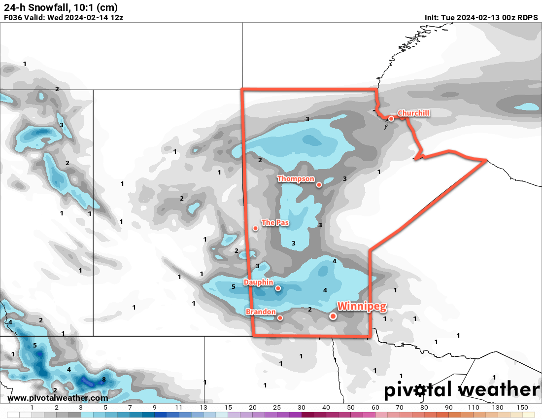
This clipper will likely bring a swath of 10 to 20 cm of snow across the central Prairies, but along the Trans-Canada Highway corridor and areas south, there’s more uncertainty with amounts and whether the precipitation will be rain or snow.

The cold snap will be short lived after this system as the upper pattern continues to favour progressive systems. Wednesday will bring below-seasonal highs to the region for another day, then a warmup begins heading towards the weekend!

Today’s seasonal daytime high in Winnipeg is -6 °C while the seasonal overnight low is -17 °C.

Light Snow Leads to Brief Cold Snap

A disturbance passing through southern Manitoba later today will bring light snow followed by moderate northwest winds. Colder air will slump into the region behind it for the end of the work week, but temperatures will rebound quickly through the weekend.

RDPS 24hr. Snowfall Forecast (10:1 SLR) valid 12Z Wednesday February 14, 2024
A low pressure system will leave a swath of fresh snow across southern Manitoba on Tuesday.

Winnipeg will sit under mainly cloudy skies today with southerly winds picking up to around 30 km/h ahead of a low pressure system moving in from the west. Temperatures will be mild with highs near -4 °C this afternoon. Light snow will move across southwest Manitoba today and reach Winnipeg by mid- to late-afternoon.

The snow will continue eastwards through the evening, tapering off to flurries overnight with around 2–3 cm of fresh snow left behind. Temperatures will dip to lows in the -10 to -5 °C range across the Red River Valley tonight.

It will be pleasant on Wednesday with highs again near -5 °C and westerly winds in the 20 to 30 km/h range. With that warmth will come more cloudy skies, though. A cold front will sweep through the region later Wednesday, bringing breezy northwest winds and cooling temperatures. Skies will likely clear out on Wednesday night, letting temperatures drop to a low in the mid-minus teens.

Thursday will finally bring sunshine to the region with northwest winds of 20 to 30 km/h and a high in the -15 to -10 °C range. Unfortunately, those winds will make it feel like it’s in the -20s. An Arctic high will continue to slump southwards through the Prairies through Thursday night; as it drops south, the winds will ease in southern Manitoba and temperatures will head to a low likely near -25 °C.

Long Range Outlook

Southern Manitoba will be under the grip of the Arctic high on Friday. The region will see plenty of sunshine with highs that struggle to climb into the -20 to -15 °C range.

The axis of coldest air will then shift off to the east for the weekend. Temperatures will return to near-seasonal values with breezy westerly winds on Saturday. The near-seasonal temperatures should persist into next week, then likely be followed with another surge of Pacific air that will send temperatures back towards freezing.

Fortunately, it looks like the region should see plenty of sun this weekend which will be a welcome change from the copious amounts of cloud cover the region has seen over the last while!

Today’s seasonal daytime high in Winnipeg is -9 °C while the seasonal overnight low is -19 °C.

Snow Tapers off With a Cooler Weekend Ahead

Lingering flurries will taper off across southern Manitoba today as the Colorado Low shifts off to the east. Behind it, northerly winds will diminish as cooler temperatures settle into the region.

RDPS 2m Temperature Forecast valid 15Z Sunday February 11, 2024
Although it won’t be particularly cold for early February, the weekend will bring cooler temperatures than the region has seen recently.

It will be the most wintery day seen in weeks across southern Manitoba today as snow tapers off and the region is left with northerly winds of 30 to 40 km/h. There may be blowing snow in western Manitoba, but the recent warmth and limited new snow in the Red River Valley should prevent it from being much of an issue here. Notable will be how much cooler it will be in Winnipeg than recently. Despite that, temperatures will stay above normal values across the region. Winnipeg’s daytime high should reach around -8 °C today and mainly cloudy skies will keep things mild tonight with a lows dipping into the -15 to -10 °C range.

Saturday will bring mostly cloudy skies to the region as an upper trough swings into Manitoba. Highs will bounce back to around -5 °C with light northwest winds. Temperatures will dip back to around -10 °C on Saturday night under cloudy skies. There will be a chance of light snow overnight as the upper trough moves through the region.

Winnipeg might see sunshine on Sunday as light southwest winds develop across the region. Daytime highs should reach back into the -5 to 0 °C range as warming moves eastwards across the Prairies with a building upper ridge. Temperatures will dip back down into the -10 to -5 °C range on Sunday night with variable cloudiness.

Long Range Outlook

The first half of next week will bring variable cloudiness to southern Manitoba with northerly winds and daytime highs in the -5 to 0 °C range. A cold front will slump into the region in the second half of the week, bringing near-seasonal temperatures as highs slump towards -10 °C along with a chance of flurries.

Today’s seasonal daytime high in Winnipeg is -9 °C while the seasonal overnight low is -20 °C.

Temperatures Return to Seasonal Values in Winnipeg

The recent cold snap is coming to an end as temperatures moderate back towards seasonal values, but with that will come plenty of cloud.

RDPS 10m Wind Forecast valid 00Z Sunday January 21, 2023
Moderate southerly return flow winds will develop over the Red River Valley on Saturday.

Heading into the end of the week, the last remnants of the Polar Vortex that have been lingering over Manitoba will finally shuffle off to the east. This will ease the cold over the region and allow temperatures to recover towards seasonal values. As the weekend progresses, a warm front will push off the Alberta Foothills into southern Saskatchewan while the Arctic front re-strengthens in the north and drops into the northern Prairies.

In Winnipeg, Friday will bring conditions on the cloudier side with a high in the mid-teens today. Like the past couple days, there’s a chance the cloud could be accompanied by light snow. The last of the cold air from the Polar Vortex will linger over the province tonight and keep overnight lows down tonight. The cloud cover will likely break up overnight and allow temperatures to dip into the -30 to -25 °C range.

More cloud will push into the region on Saturday as the warm front creeps across southern Saskatchewan. The return flow from a departing high will intensify over the Red River Valley, strengthening southerly winds up to the 40 to 50 km/h range through the day. Highs will climb back to around -15 °C, but wind chill values will be notable making it feel closer to -25. In addition to the chill, those southerly winds will likely produce areas of blowing snow through the Red River Valley; any blowing snow would likely be at its worst from the early afternoon to the evening.

Those winds will begin to ease on Saturday evening as the warmer air finally reaches the valley. Light snow will likely move through overnight with temperatures staying steady in the mid-minus teens.

Winds will continue to ease on Sunday with cloudy conditions across the Red River Valley. Highs will creep upwards again, likely reaching around -10 °C in Winnipeg and area. More light snow is possible on Sunday night with temperatures dipping back towards -15 °C.

Long Range Outlook

There is disagreement between weather models on how next week will turn out. Canadian weather models are pushing Arctic air further south and giving Winnipeg highs in the -15 to -5 °C range through the first half of the week, while other models bring highs of -10 to 0 °C into the region next week.

Either way, plenty of cloud cover will come along with that milder pattern. The warmer weather will likely stick around to the end of the week.

Today’s seasonal daytime high in Winnipeg is -13 °C while the seasonal overnight low is -24 °C.