A very cool Halloween evening is ahead in the Red River Valley thanks to a large high pressure system from the Arctic that will slowly move out of the province through the day. Unfortunately, as it begins to move out this evening, a fairly breezy southerly wind will develop and make things feel even colder than they already are.
Today will be a very chilly day with temperatures struggling to reach a daytime high of just 1 or 2°C thanks to a substantial amount of colder air that has pushed into the province with an Arctic ridge that’s moving through. Winds won’t be too bad this morning, but through the afternoon – as the ridge moves southeastwards into Minnesota and NW Ontario – southerly winds will strengthen to about 30km/h with gusts to around 50km/h.
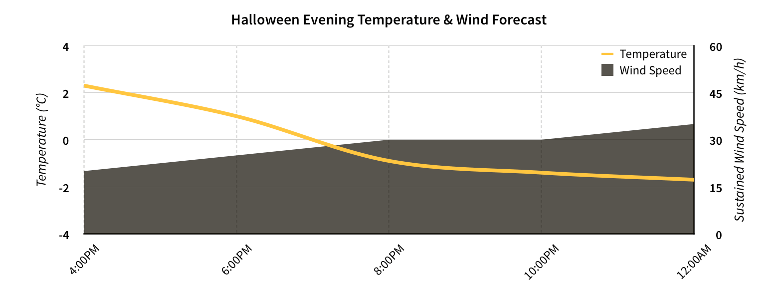
Temperatures will quickly drop to just below freezing this evening which, when combined with the ≥ 30km/h winds, will feel closer to the -8 to -10°C range. For anyone heading out, it will be quite a cool evening and be sure to bring some gloves and toques to keep warm.
Temperatures will drop to around -3°C overnight with the wind persisting.
Warming Through the Weekend
Temperatures will slowly climb as warmer air begins working into Manitoba from the west. Saturday will be another windy day with southerly winds at 30-40km/h with gusts as high as 60km/h. The temperature will climb to around 4°C for a high, but will certainly feel cooler than that with the strong winds. There will be a few clouds through the day, but it will be a relatively sunny day overall. The temperature will drop to around -2°C on Saturday night.
Sunday will bring the warmest weather in a while with temperatures climbing into the upper single digits. Winds will be lighter than Friday or Saturday which will make that warmer temperature feel more pleasant. Skies will be much cloudier and there may even be a very slight chance of a shower. Sunday night will see temperatures drop to 1 or 2°C with an increased chance of some shower activity.
Unsettled Week Ahead
The warmth and cloud reaching us by the end of the weekend is thanks to a developing low pressure system in Montana that is forecast to push into Manitoba early next week. There’s significant uncertainty to where and/or how much precipitation will fall, but at this point it looks like Winnipeg will see some share of the unsettled weather on Monday and Tuesday.
Temperatures for much of the week look to be near-normal[1] but there are hints that a significant low pressure system is possible at the end of the week that could bring Southern Manitoba its first wintery blast of the year. A lot can change between now and then, though, so we’ll just keep an eye on things for now and enjoy the warmer end to the weekend ahead!
- Normal daytime highs heading into the beginning of November are around 3 or 4°C. ↩