Hot and humid conditions will continue this week in Winnipeg with the occasional chance of thunderstorms.
We’re back! This hiatus was longer than originally thought, but between minor burn-out with work, minor health concerns, travel, and a busy family schedule, there wasn’t much left in the tank by the time I could sit down and write. Things are in a better spot now, though! I’m rested — I was fortunate to be able to take much of July off — and the schedule is calming down. I hope to be back to writing twice weekly, but we’ll see how the summer schedule goes. That said, I’m starting this post off wanting to write instead of feeling like I have to write, which is a good start.
And what a day to get back at it. It will be a hot one in Winnipeg today as a low pressure system pushing into central Manitoba draws a hot air mass into the southern reaches of the province. Daytime highs will climb into the low 30s in the Red River Valley with muggy conditions as dew points climb back above 20 °C. The heat and humidity will combine to make it feel closer to 40 this afternoon.
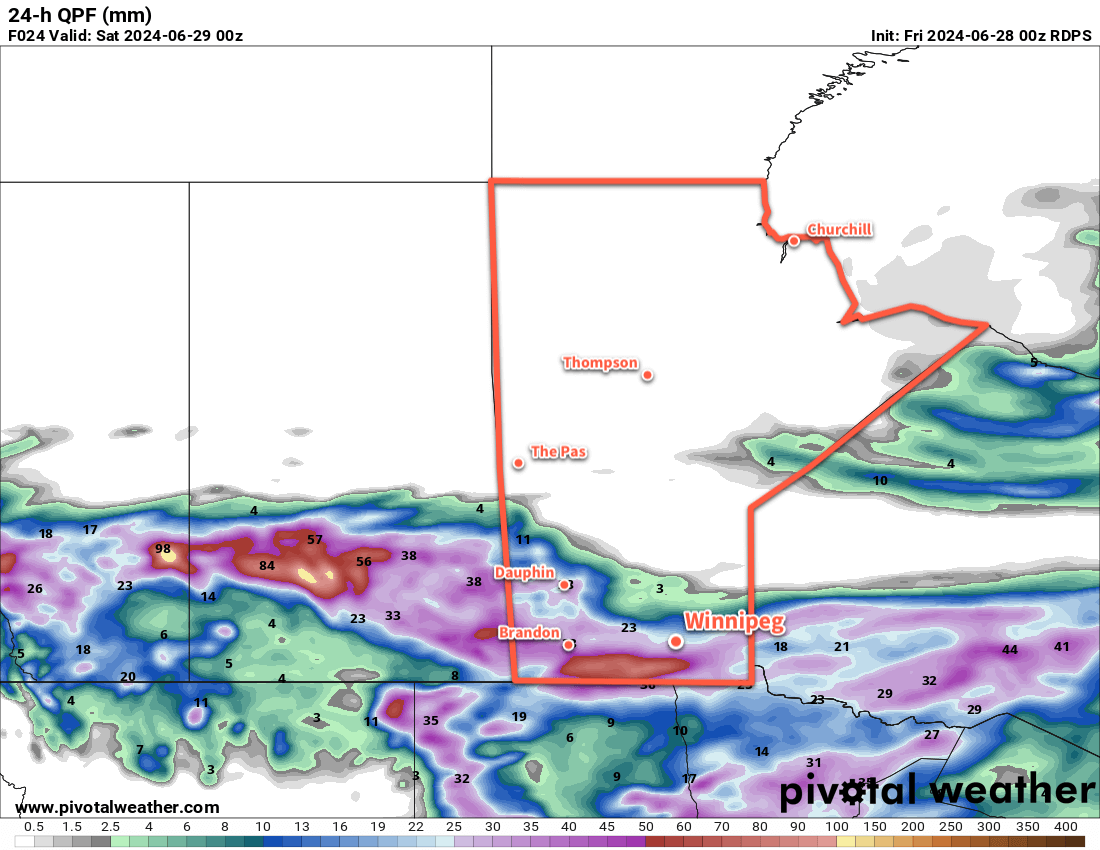
Heading into the evening, a trough of low pressure will begin digging into this hot and humid air mass from the west. The environment over southern Manitoba will be primed for strong to severe thunderstorms. It will be an extremely unstable air mass characterized by MLCAPE values in excess of 2,500 J/kg and winds over the region will produce 20 to 30 knots of deep shear and be favourable for discrete supercell development. If any thunderstorms are able to develop along this trough, it is likely that they will quickly become severe thunderstorms capable of torrential rain, large hail, damaging wind gusts, and pose a low risk of a tornado.
All that said, though, it remains a low risk. By late in the day, a mid-level axis of warm air will be positioned over the region, and warm air aloft will work against the development of thunderstorms. With the potential potency of thunderstorm activity later today and its uncertainty, be sure to stay aware of any alerts that may be issued later today by the Meteorological Service of Canada.
If thunderstorms develop, the activity could persist into the overnight period, weakening as the night goes on.
Tomorrow will be another mainly sunny and hot day. The trough of low pressure will linger in the region, but much of the Red River Valley will sit west of it; this will give northwest winds to much of the region, bringing a slight easing of the humidity as dew points drop back into the upper teens. Daytime highs will climb back into the upper 20s with partly cloudy skies. There is a slight risk of a thunderstorm later in the day, but much of the instability will have shifted east and the likelihood looks low.
Thursday will bring sunny skies to the region as temperatures head back into the low 30s. The humidity will likely continue to ease, making for a less muggy day than the region will see today.
All three nights — tonight, Wednesday night, and Thursday night — will bring lows in the upper teens or low 20s and light winds.
Long Range Outlook
Friday will bring more heat and sunshine to the region with daytime highs near 30 °C, but with less humidity than seen through the earlier parts of the week. Sometime Friday night or early Saturday, a cold front will push through southern Manitoba and bring a chance of showers or thunderstorms. Behind it, conditions will settle and temperatures will return to seasonal values.
A stretch of seasonal temperatures is expected to persist through the weekend and into next week. This, unfortunately, could result in forest fire smoke from western Canada spreading into southern Manitoba. It’s too early to tell, but keep in mind that those cooler temperatures could come with degraded air quality.
Stay cool today, check on those you know who don’t have A/C, and have a good week!
Today’s seasonal daytime high in Winnipeg is 26 °C while the seasonal overnight low is 13 °C.