Unsettled and Cool Weather Ahead

Several disturbances moving through Manitoba will bring chances of rain and cool weather through the rest of the week.

RDPS 24hr. Precipitation Accumulation Forecast valid 06Z Thursday, May 2, 2024
Showers will lift through southern Manitoba on Thursday, but may break apart over the Red River Valley.

A large upper-level vortex situated over southern British Columbia and Alberta will gradually shift east this week. As it trundles across the Prairies, it will bring seasonably cool conditions as a series of disturbances track across southern Manitoba.

Before any more inclement weather, Winnipeg will see a comparatively pleasant day today. A ridge of high pressure over the region will bring sunny skies and light easterly winds as temperatures climb into the low teens.

The first disturbance will begin to impact the region tonight; a low pressure system crossing the Dakotas will support an area of thunderstorms south of the border, with moisture streaming northwest along a trough of low pressure hanging back into central Saskatchewan. Cloud will spread into southern Manitoba tonight, followed by a broken band of showers pushing north on Wednesday morning. Temperatures will drop into the mid-single digits.

On Wednesday, showers will weaken as they push north into Manitoba. As the thunderstorms in the United States pull off to the east, they will take the moisture supply with them. This will leave the showers back in the Prairies with less support and they will continue northwards as a weakening band.If a small shortwave manages to eke its way northwards, it could support a more organized, sustained area of showers. Not much rain is likely with these showers, though, with most areas seeing less than 2 mm of precipitation.

On Wednesday afternoon, a few thunderstorms are possible over southeast Saskatchewan and western Manitoba; no severe weather is expected with these storms and they should taper off before they reach the Red River Valley. Temperatures will climb to a high in the mid-teens on Wednesday afternoon. Skies will clear for Wednesday night with a low temperature dipping down into the 0 to 5 °C range.

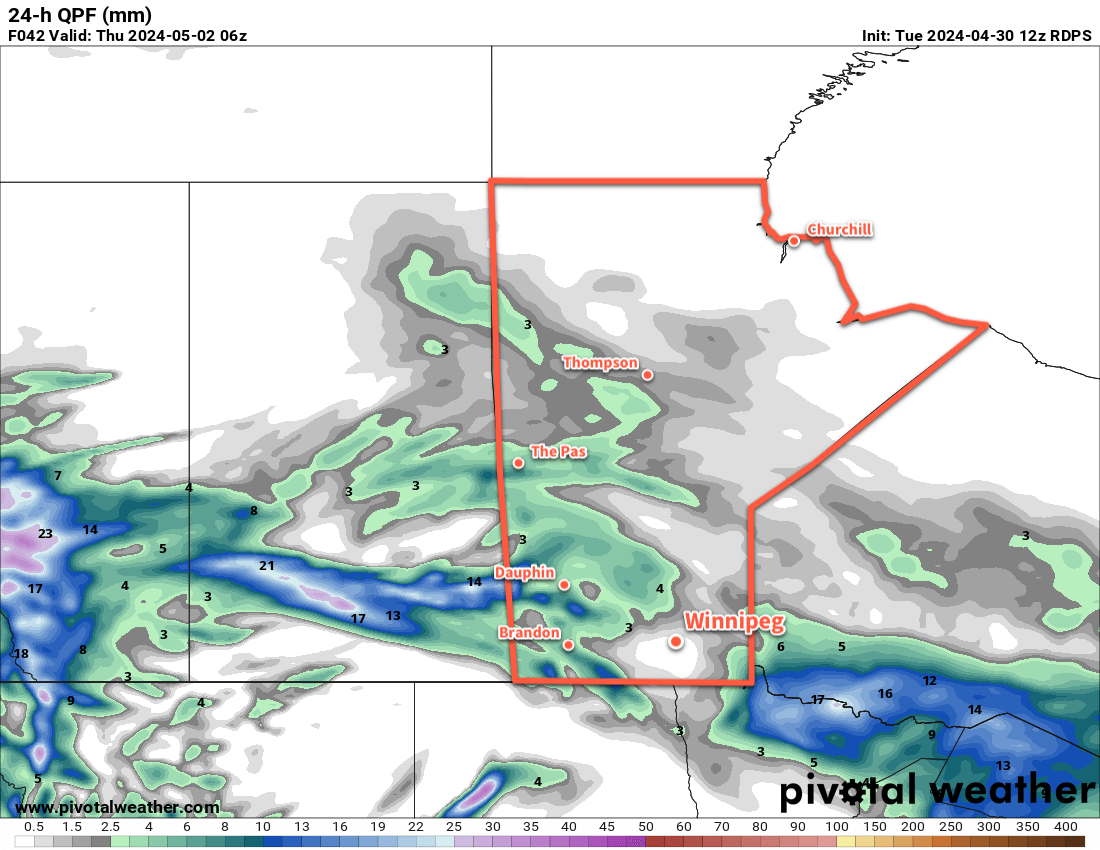
On Thursday, skies will cloud back over as another disturbance ejects northwards out of the Dakotas into Manitoba. Showers will push over the border early in the day, spreading north-northeast through the day. Most areas will see rain on Thursday as a low pressure centre gradually forms over North Dakota and Minnesota. Showers will continue through Thursday night, bringing wet weather all the way into Friday morning. This system could bring anywhere from 5 to 30 mm of rain across southern Manitoba; in Winnipeg there’s uncertainty as it will depend on where the showers enter the region early Thursday. If they arrive further east into the Red River Valley, the city could see as much as 15 to 25 mm of rain; if it’s further west and moves into the province over southwest Manitoba, then amounts will likely end in the 10 to 20 mm range.

Temperatures will climb into the low teens on Thursday, then drop into the mid-single digits on Thursday night.

Long Range Outlook

The rain will taper off across the region on Friday, but scattered showers may linger into the evening. Temperatures will climb back into the low teens with breezy westerly winds, then drop close to the freezing mark on Friday night.

Heading into the weekend, skies will begin to clear on Saturday, then sunnier conditions will return for Sunday as the upper vortex finally moves off and a ridge of high pressure moves back into the region. Temperatures on Saturday will be seasonably cool, but Sunday should bring milder temperatures back to the region.

Unsettled weather returns Sunday night into Monday as another low moves into the Prairies. This system will support a large area of elevated convection that will develop on Sunday night then lift northeast into Manitoba on Monday.

The region will likely see more rain through the day on Monday as this system moves through, and then it looks like things will settle down for the rest of the week with near-seasonal temperatures.

Today’s seasonal daytime high in Winnipeg is 16 °C while the seasonal overnight low is +2 °C.

Showery Friday Leads to Seasonal Weekend Temperatures

Unstable conditions across southern Manitoba will support areas of showers that move through the region today. The rain will clear out this evening, leaving behind near-seasonal conditions for the weekend.

24-hour Forecast Precipitation Accumulation valid 12Z Saturday April 27, 2024
High-resolution weather models show rainfall accumulations across much of southern Manitoba over the next 24 hours.

A stalled frontal boundary slowly collapsing over southern Manitoba will spread showers across the region today. Initially, a band of showers west of the Red River Valley will shift into the region through the morning. As the day progresses, another wave of showers will lift northwards out of the United States as a low pressure system moves from Nebraska towards Minnesota. These two areas of showers will merge over south-central and southeast Manitoba by the evening, then slump southeast through the night.

These showers could bring a widespread 10 to 25 mm of rain to many parts of southern Manitoba today, but will quickly weaken heading into the night. WIth the cloud and rain, temperatures will be cooler with highs in the low teens. For those who have found the dry conditions lately irritating, dew points in the mid-single digits will be a welcome relief.

A cold front will push through in the second half of the night, ushering in northerly winds and a cooler air mass. Temperatures will fall to a low in the mid-single digits tonight.

Skies will clear out on Saturday as an area of high pressure moves into southern Manitoba. Temperatures will rebound to a high near 10 °C with northerly winds increasing into the 30–40 km/h range in the morning, then weakening. A ridge of high pressure will bring mainly clear skies on Saturday night with a low dipping to near 0 °C.

On Sunday, another low pressure system will lift towards Minnesota. This will bring increasing cloudiness to southern Manitoba as easterly winds pick up into the 20–30 km/h range. High temperatures will climb back into the low teens on Sunday afternoon.

On Sunday night, more rain will move into southern Manitoba from North Dakota and Minnesota. As the night progresses and temperatures drop, though, the rain may change over to wet snow. Temperatures will drop into the low single digits with light northeast winds on Sunday night.

Long Range Outlook

A rain/snow mix will shift east out of the province on Monday, leaving behind as much as 5 to 15 mm of a sloppy rain/snow mix. It will be a cold April day on Monday with a high temperature in the mid-single digits.

That system will barely have cleared out on Monday before another disturbance moves into the region on Tuesday. This will bring more rain showers to southern Manitoba as temperatures return to seasonal values.

Heading into the latter half of next week, the weather pattern looks to settle down and the region will shift into a seasonal to seasonably mild pattern.

Today’s seasonal daytime high in Winnipeg is 14 °C while the seasonal overnight low is +1 °C.

Southern Manitoba 2013 Thunderstorm Season Statistics

Editor’s Note: The following is a guest post by @jjcwpg, originally posted here and has been updated with some relevant links from A Weather Moment.


July 13, 2013 southwestern Manitoba; most significant storm event of season; @lovestormsmb and I were there.

For the 4th consecutive year, I have gathered statistics on thunderstorm and severe thunderstorm frequency across southern Manitoba. An explanation of how I gathered these statistics as well as notes on accuracy can be viewed here. I have divided southern Manitoba into 6 regions: west, southwest, south, southeast, east and Interlake. These regions can be seen here. I understand the zones are not equal in size; I plan to try to improve this next year. Lastly, I’d like to thank you in advance for taking the time to read this post as it is one of my favourite posts of the year!

Number of days in 2013 thunderstorms were observed in each region.

The 2013 thunderstorm season was less active than in 2012 in all regions of southern Manitoba. The greatest decline in thunderstorm days was in the Interlake, southeast and east parts of Manitoba where in some cases there were more than 10 thunderstorm days less than in 2012. The Interlake saw the greatest decline, dropping from 67 thunderstorm days in 2012 to only 55 this year. In total, there were 89 thunderstorm days across southern Manitoba this year, compared with 109 last year.

One reason for the decline is because 2012 had a very long thunderstorm season, lasting from March to November. This year, the first thunderstorm did not occur until April 30, and the last on October 11 putting the season at 165 days long, compared with 237 days last year.

The season began quite late in some areas this year, in large part thanks to an incredibly late spring. The South, Interlake and East zones did not see their first thunderstorm until May 14, 2 months later than last year. On a more local scale, Winnipeg saw its first t-storm on June 10, the second latest start to the thunderstorm season since 1953.

Number of days in 2013 a severe thunderstorm warning was issued for each region.

Again in Winnipeg, there were only 17 thunderstorm days this year at the airport, tying for 4th least in a year since 1953. It just so happens that one of the years we tied with was 2011. This really follows the trend of the past few years of below normal thunderstorm activity in the city. The last time we had an above normal season was 2007. The last 6 years have averaged some 6 days below the 1981–2010 and 1971–2000 normal of 26 to 27 days.

In comparison, Brandon had 23 thunderstorm days this year, and I recorded 20 here in south St Vital.

The map to the left shows the number of days with a severe thunderstorm warning issued by Environment Canada in each warning zone. It appears southwestern Manitoba was the busiest this year for severe thunderstorms. The season in Manitoba lasted from June 9 to September 26, or 110 days, compared with 116 days last year. Click here for a map of the length of the severe thunderstorm season in each warning zone this year.

Number of days a tornado warning was issued in each region through 2013. Also plotted are confirmed and unconfirmed tornado events.

The last map I have is of tornadoes, as seen to the right. The colours in the warning boxes represent the number of tornado warning days this year, and the dots represent unconfirmed (possible or probable) and confirmed tornadoes (coloured by intensity). Only 4 tornadoes were confirmed, but many more may have touched down.

The most notable twister was in Sioux Valley, First Nation, west of Brandon on July 18. It was a strong EF–0 tornado, and moved right through town, destroying a few homes and leaving a few injured. Other than that, the most significant potential tornado event was in the Pipestone to Hartney area on July 13. Significant damage occurred in the area, including to the arena in Pipestone which half of it had been flattened. It is still up in the air wether a tornado occurred or not. Either way, according to Discover Westman, some recall the storm as being the worst storm in recent memory in southwestern Manitoba.

The storm also only worsened the flooding conditions in Reston, which saw yet another round of biblical rains with the storms. In fact, the town had received about 352 mm of rainfall in just a 24 day period from June 20 to July 13 according to Manitoba Agriculture.

In addition to the rains and winds, 9 cm diameter hail was measured in southeastern Saskatchewan with the storms.

Lastly, the following graph summarizes the number of thunderstorm days, severe t-storm warning days and tornado warning days across all of southern Manitoba per month:

Summary of all thunderstorm statistics for all of Southern Manitoba broken out by month.

Thanks for reading! A summary of the severe storm season across Canada will come late next week.

Winnipeg Hammered By Torrential Rain; Thunderstorm Threat Continues Through Weekend

Portions of Winnipeg experienced a tremendous amount of rainfall yesterday evening as a thunderstorm developed over the southern half of the city and sat in the same spot for over an hour. While many areas in the city saw less than 10mm of rainfall, reports of localized flooding were numerous as rainfall rates that climbed as high as 300mm/h dumped between 50–80mm of rain over a small area of southwestern portions of the city.

image-1

24hr. rainfall accumulations from Thursday evening. Given that we had no significant precipitation on Wednesday in Winnipeg, this is effectively the rainfall accumulations for Thursday’s thunderstorm in Winnipeg. Amounts outside Winnipeg wiil be representative of the full 24hr. period.

The storm moved into Winnipeg around 7:15PM Thursday evening as a small thunderstorm southeast of the city near Ils Des Chene moved northwestwards toward another thunderstorm stationed over Headingly that had been warned for producing heavy rainfall in that area. By 7:40PM, the storm west of the city merged into the storm inside the city and intensified. At this point, everything stopped moving.

image-2

Flooded Roads on Sterling Lyon Parkway; Photo courtesy @shelzolkewich.

In an area roughly bounded by McGillvery Blvd., Pembina Highway and Portage Avenue, the rain simply kept coming and coming. Numerous reports started showing up under #MBstorm on Twitter. Early on it was clear that areas near Kenaston & the Sterling Lyon Parkway were being hit very hard with photos coming in showing flooded roads with water as much as just over a foot deep.

Reports began to come in of actual rainfall amounts, too. @robsobs, a very reliable source for rainfall data in SW Winnipeg (as well as the person who runs the excellent Rob’s Blog reported a peak rainfall rate of 300mm/h under the heaviest rainfall. Near the end of the event, he reported a total of 69mm that fell over the course of 2 hours:

In addition to roads being flooded, there were numerous reports of ditches & pools overflowing. The heavy rainfall also impacted one of Winnipeg’s newest and largest stores: IKEA. The IKEA on Kenaston was evacuated yesterday evening as water began pouring into the main floor of the store:

It may not have seemed like a day where severe weather was likely since skies were mostly cloudy through the day and temperatures climbed only into the mid–20’s. There was plenty of moisture building into the region, though, and many of the conditions we look for with convection were in place.

image-3

Another shot of the flooding on Sterling Lyon Parkway. Photo by @tracylkj.

While we didn’t have enough sunshine to get the storms started, a strengthening trough of low pressure laying across the Red River Valley managed to initiate storms which then fed off the abundant low-level moisture and produced just one significant storm that impacted Headingly and Winnipeg. The Winnipeg region was included in our Slight Risk area on Thursday morning.

Friday


26°C / 16°C
A mix of sun and cloud. Small chance of thunderstorms in the afternoon & overnight periods.

Today will be a warm, humid day with temperatures climbing once again to around 25–26°C and with dew points hovering in the 18–20°C range. Once again we’ll see a risk of thunderstorms develop in the afternoon as the atmosphere destabilizes. The key ingredient for today’s threat will be our daytime high. If dew points stay close to 19 or 20°C and we can get to 27°C, we’ll see a much greater chance of thunderstorms than if the dew point is closer to 18°C and we stay near 25 or 26°C. Should storms develop in the Red River Valley, they’ll see a potent environment to develop in with substantial instability aloft and CAPE values of nearly 2500J/kg. The big limiting factor in their development will be the near absence of shear. The wind will be extremely light below 500mb which will make it very difficult for storms to develop the structure required to make them long-lasting entities. As such, any storms that develop in the afternoon will likely be pulse-type storms whose main threats would be heavy rain and/or large hail.

By the evening another round of elevated convection looks to fire up and lift northwards. It may end up west of, over, or east of the Red River Valley. It’s simply too early to tell at this point. We’ll be sure to update our thoughts below as things become more clear. We’ll head to an overnight low of around 16°C tonight.

The Weekend

Saturday

23°C / 14°C
A mix of sun and cloud. Chance of a shower.
Sunday

23°C / 12°C
Mainly cloudy. Showers or thunderstorms likely.

We’ll see the main upper low that’s been pulling moisture northwards and setting up our instability begin to work it’s way eastwards through the Prairies this weekend. Saturday actually looks to be a fairly nice day; dew points will drop towards the mid-teens and we’ll see a slightly cooler high of around 23°C under a mixed sky. There will be a slight chance of showers as a trough swings through, but things seem stable enough that they would be fairly scattered and light. Saturday night will see some cloudy periods with a low of around 14°C.

On Sunday we’ll likely see showers and thunderstorms as the upper low moves over us. Things will destabilize under the upper low early in the day and the relatively warm, moist air mass should have little trouble supplying enough instability and moisture to get things going. No severe weather is expected. Sunday will mark the return of dryer air into the Red River Valley.