A couple more days of unsettled weather will give way to some of the warmest temperatures of the year.
The main weather story will be gradual improvement as the week progresses. Currently we’re under the influence of a broad trough of low pressure that has brought scattered showers to the Red River Valley over the past couple days.

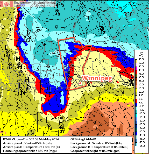
Multiple bands of precipitation will be in place over Southern Manitoba today thanks to multiple disturbances and a fair amount of instability. As the upper-level flow finally organizes itself, a Colorado Low eject northeastwards on Thursday bringing potentially significant rainfall to the Red River Valley and Southeastern Manitoba. The unsettled weather will linger through Thursday night but then a weak ridge of high pressure will begin building in from the west, bringing more settled weather with relatively warm temperatures, especially compared to what we’ve been suffering through so far this spring.
Today
Today will bring mainly cloudy skies to the Red River Valley as a large low pressure complex stretching from Northern Saskatchewan to Colorado slowly begins organizing itself. More organized showers will fall through much of the day west of the Red River Valley through southwest regions and the Parkland with total accumulations around 5-10mm, but here in the valley we will likely only see scraps of elevated convective showers occasionally moving over the area.
I say likely since there is pretty high uncertainty in exactly how this system will evolve today. The band of showers to our west will slowly creep eastwards towards the RRV through the day and likely push into the western Red River Valley this afternoon. There’s a chance that it will continue pushing eastwards, and if that’s the case then we might see some more organized precipitation later in the afternoon into the evening. There’s also a very outside chance that this whole thing bumps eastwards mid-morning and we’re the ones stuck under the showers for the day.
Complicating matters will be a secondary band of precipitation that will develop this afternoon and lift northwards out of North Dakota and Minnesota. It’s currently forecast to just clip SE Manitoba, but if the upper level trough tilts a bit more, which it has been doing more than the models have been forecasting for 2 days now, that band of rain could end up inside the Red River Valley.
As a third complicating factor, there seems to be fairly unstable mid-levels over most of Southern Manitoba, so even if the precipitation stays to our west and east, there will still be a chance for some light showers zipping across the valley.

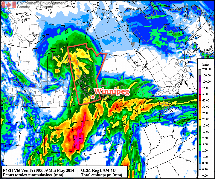
It’s a very complicated setup; most models agree that there will be rain on the western and eastern fringes of the Red River Valley with little in between[1], however slight variations in the actual positions of systems could change things quite dramatically. For that reason I’m say that there’s a good chance we’ll see occasional showers today. We may see more, we may see less, but this is a situation where trying to be any more specific than that will likely be a futile effort.
What is a little more certain is that we’ll see a high near 12°C today with light southeasterly winds.
The threat for showers will continue through the overnight period through most of the Red River Valley. We’ll drop to a low around 5 or 6°C with winds shifting around to the north.
Thursday
Thursday looks to be the most active day. A strong Colorado Low will track into Minnesota, spreading rain ahead of it into Southern Manitoba. Moderate instability aloft coupled with strong lift and enhanced convergence thanks to the deformation zone will result in showers, potentially fairly heavy at times, through much of Southern Manitoba. There may even be a very slight chance of a rumble of thunder or two.
The wet weather will likely last through much of the overnight period as well. By the end, anywhere from 5-15mm of rain seems likely over the Red River Valley; amounts will likely vary over short distances, and it’s impossible to say where will see the most rain until we’re closer to the event. I’d really love to be more specific, but with this rapidly developing, complex system, the models can be quite misleading and the best forecast will come from observing what’s actually happening and how things are developing in real time.
The high temperature on Thursday will be near 11-12°C once again, and the overnight low near 5°C.
Friday and Beyond
The weather finally looks to turn towards a more pleasant pattern for the end of the week. A cut-off cold low will spin aimlessly over the northwestern Prairies, leaving us on the warmer side of things as slightly milder air manages to work its way into the region. No substantial warm push is on the way, but with the cold air locked up well to our northwest, temperatures should manage to climb to around 15-16°C on Friday, Saturday and Sunday.
It seems quite likely that we’ll see our warmest day of the year this weekend. Currently, the warmest day we’ve had was a mere 15.1°C on April 23rd, but Saturday looks likely to beat that by a degree or so. Overnight lows are expected to sit near 5-6°C through Friday, Saturday and Sunday, which will be right around normal for this time of year.
Skies should be mainly sunny on Friday and Saturday, however we will likely see some cloud and a very slight chance of a shower on Sunday as a weak low pressure system pushes into western Manitoba.
- And I’m inclined to believe it given how often any sort of convective precipitation manages to end up on either side of Winnipeg. ↩
