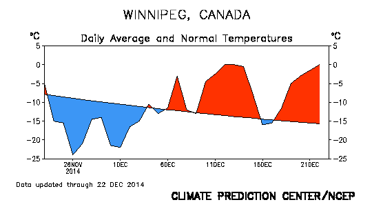
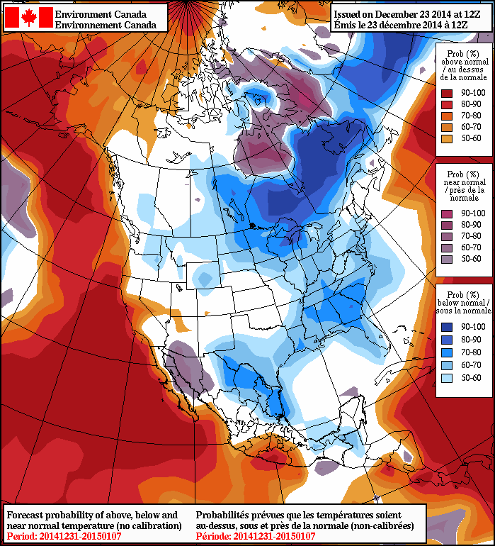
After a prolonged period of temperatures some 10 to 20°C above normal, Winnipeg & the Red River Valley is set for a rude awakening after Christmas as Arctic air plunges southwards and brings below normal temperatures to the region.

The crash to colder temperatures will be exceptionally jarring considering the abnormal warmth we’ve seen through much of December. Leading up to Christmas, mild weather will persist as an incoming low pressure system helps extend the stay of the warm air that’s been so common the past few weeks. As the system passes on Christmas Eve, though, a major pattern change is set to take place as our fairly weak is absorbed into the rather major East Coast “Santa Bomb” which in itself will induce a shift to the gradual re-establishment of the Polar Vortex over Hudson Bay.[1]
Christmas Eve
Today will be a pleasantly mild day with highs near –3°C through the Red River Valley and winds developing out of the south to around 20–30km/h. Skies will remain mainly cloudy in advance of the incoming low pressure system with some flurry activity finally pushing into the Red River Valley by late in the afternoon and reaching Winnipeg by evening. Little is expected as far as accumulations go; the main accumulating snowfall will remain north of the Trans-Canada corridor through the Parkland and Interlake regions eastwards into Ontario where around 2–4cm are expected.
Temperatures will drop to around –6°C tonight with winds shifting to the west-northwest at around 20km/h.
Freezing drizzle will once again be possible overnight into Christmas morning as saturated low-levels are left behind the departing low pressure system. Steep low-level lapse rates and only a relatively light wind from the NW may result in another batch of road-slicking freezing drizzle. Due to its nature, freezing drizzle requires a fairly delicate balance of factors to exist, so there will be unavoidable uncertainty until later tonight, but keep in mind that it is a distinct possibility.
Christmas Day
Christmas Day will be a mixed bag in Winnipeg. Temperatures will remain above-seasonal, but the push of cold air will already have begun. As a result, temperatures will likely remain steady near –5°C as any potential daytime heating is offset by the cooler air moving in. Freezing drizzle is possible through the morning hours, while flurries are more likely through the afternoon.[2] Skies will remain mainly cloudy, although a brief glimpse of sunshine is possible.
Temperatures will head down to the –12°C mark or so overnight with a continued chance for flurries and gradually diminishing cloud.
Boxing Day
Boxing day will be when the real surge of Arctic air begins pushing in. Expect mixed skies with a chance of flurries through much of the day. Temperatures will drop through the day to around –16°C by evening. Skies should clear out overnight as the Arctic ridge begins moving in and temperatures drop to around –24°C. This will be the coldest overnight low we’ve had since November 30th into December 1st when the temperature dipped to –27.1°C. Given that the normal overnight low for this time of year is –22°C, that’s not too bad.
Cold Pattern Persists
The cold weather will be here to stay for a while as a persistent northwesterly flow develops over the province thanks to gradually establishing polar vortex over Hudson Bay.

In the end, it means a relatively dry pattern with daytime highs generally in the –15 to –20°C range.[3] This pattern looks to continue at least until late next week, so dig out those real winter clothes again and get the block heater ready, winter’s on its way back.
$.bigfoot()
- The persistent vortex over Hudson Bay – for all intents and purposes a “polar vortex” – is a regular occurance over Hudson Bay in the winter months and is the most common cause for prolonged cold weather in Southern Mantioba. ↩
- If things end up just a tad cooler, the freezing drizzle risk could be just a chance of flurries; if things end up a tad warmer, the freezing drizzle risk could persist through much of the day. ↩
- …or a tad cooler. ↩
