Manitobans can enjoy slight relief from the bitter cold that has been in place the last few days as more seasonal temperatures are in place thanks to a fairly large low pressure system passing through Hudson Bay that has dragged the warm air all the way east from the Rocky Mountains. Unfortunately, the milder weather will be short lived as a series of cold fronts sweep southwards into the United States ushering the colder air back into the region.
Temperatures will climb to around –11°C today with mixed skies as a warm front slides through the region from the northwest. There will be a slight chance of flurries, particularly first thing in the morning and again in the evening into the overnight period, but otherwise it will be a seasonally nice day with westerly winds at 30–40km/h. Expect temperatures to drop to around –17°C tonight.
Thursday will be a bit of an in between day; a weak cold front passing through will bring daytime highs cooler than Wednesday – somewhere around –14°C or so – and a fairly sunny start to the day. By the afternoon, more cloud should begin working its way in from the west alongside the next low approaching from Saskatchewan. Little in the way of snow is expected here on Thursday or Thursday night and winds will be relatively light. Temperatures will dip back down to –17°C once again on Thursday night.
Friday will be the sunniest day of the second half of the week. A slight chance of some morning flurries will quickly clear out as we head to a high of around –15°C with light winds. However, a storm is brewing, and by Friday evening an Alberta clipper will be making its way into Southern Manitoba, set to pack a compact wallop as it moves through Friday night and Saturday.
End-of-Week Alberta Clipper Brings Winter Storm to Manitoba
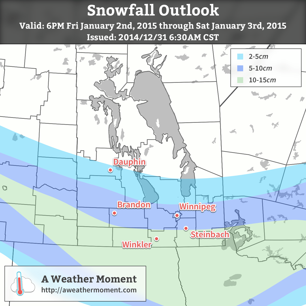
An Alberta Clipper is forecast to track across Southern Manitoba Friday night into Saturday, bringing with it a significant shot of snow, strong winds, and then a plummet back into frigid Arctic air.
Note: Alberta clippers are compact systems whose impact depends significantly on their track. As we’re still several days out from this system, please take the following as just general guidance and remember that with a slight change in track, significant changes in the weather could be seen for any one location.
Snow will spread eastwards into southwestern Manitoba and the Parkland region on Friday evening, progressing across the remainder of the province through the evening hours. A relatively sharp deformation zone will set up across the Parkland & Interlake regions, limiting the northward extent of the snow. While many regions will see accumulating snow, the greatest amounts will be along the Trans-Canada corridor and the western escarpment of the Red River Valley.

By the time the snow stops on Saturday evening, around 10–15cm of snow may have fallen in a large swath encompassing much of the Trans-Canada corridor and areas south to the U.S. border. An area of higher snowfall will likely develop somewhere near the US border, perhaps just south into North Dakota, depending significantly on where & when the system pivots and begins heading E/NE instead of SE. In the core of heaviest snowfall, as much as 15–25cm of snowfall looks possible. Much of the Parkland and southern Interlake will see between 4–8cm, with amounts tapering off fairly quickly north of that.
In addition to the snow, this system will have fairly strong winds associated with it. Ahead of the low, easterly to northeasterly winds will strengthen to a gusty 30–40km/h. As the system passes through, winds will strengthen out of the northwest to around 50km/h with gusts as high as 70–75km/h. The strong northwesterly winds coupled with the ample fresh snow will likely produce blizzard conditions and make travel dangerous on Saturday. If you have travel plans, make a plan B in case this forecast happens to be right.
Temperatures will reach a high around –15°C on Saturday and then plummet to around –30°C on Saturday night with wind chill values near –45. Sunday looks clear and bitterly cold with a high of only around –26°C coupled with 20–30km/h winds that will produce wind chill values in the –35 to –40 range. If these wind chill values materalize, we’ll likely see extreme cold warnings issued for much of Southern Manitoba through the weekend.[1]
As mentioned, there is potentially significant variability to this forecast and what I’ve presented is the current most likely scenario. I’ll be keeping tabs on this system through the week and provide updates in the comments below and another full look at it in Friday morning’s blog post.
- If the extreme cold occurs while blizzard conditions are ongoing, the blizzard warning would “include” the extreme cold. ↩
