Mild But Dreary Weather Continues

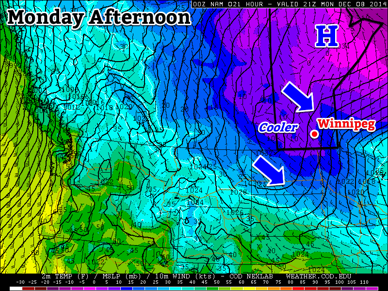
The weather pattern that has brought temperatures well above seasonal to Winnipeg[1] – despite the persistence of low cloud supplied by the outflow winds of a high pressure system to our southeast – will continue to pump warm Pacific air eastwards into the region for another couple days. By the end of the weekend, however, a cold front is set to push through bringing more seasonal temperatures back to the Prairies.

Friday
1°C / -2°C
Mainly cloudy
Saturay
3°C / -3°C
Mixed skies
Sunday
-1°C / -13°C
Mainly cloudy; slight chance of flurries

Winnipeg will see cloudy weather today as low cloud entrenched in the Red River Valley refuses to exit as southerly outflow winds continue to reinforce the low-level moisture trapped underneath the substantially warmer air just off the surface[2] that has spread over southern Manitoba.

The cloud will be accompanied by breezy southerly winds to 30-40km/h. The temperature will only climb to around 0 or +1°C today. Some clearing is possible later in the day as drier air begins pushing eastwards into the Dakotas and may work its way northwards in the flow. It’s far from certain, but we could see some breaks in the cloudy skies later today into the evening. Temperatures will drop to around -2°C tonight.

This Winnipeg forecast sounding – valid at 10AM CST Friday, December 12, 2014 – shows a thin layer of saturated air right at the surface which will continue to produce low-level cloud.
This Winnipeg forecast sounding – valid at 10AM CST Friday, December 12, 2014 – shows a thin layer of saturated air right at the surface which will continue to produce low-level cloud.

Saturday looks to bring mixed skies with a lot of uncertainty on exactly what we’ll see. Weather models want to clear things out fairly well and give us sunny skies with a high near 6°C. Unfortunately, I’m not entirely convinced that’s what will happen. The Red River Valley will sit on the cusp of where the return flow from the high pressure system meets drier air pushing in from the southwest. However, a low pressure system approaching from the west will likely back the winds slightly, tapping into the low-level moisture in the outflow winds from the high. Additionally, large-scale lift ahead of the low could also work to develop more low cloud ahead of the approaching cloud. So while the day may end up sunny, it seems a bit more likely we’ll see mixed skies or increasing cloud through the day. Due to that, I think the high will be closer to 3 or 4°C with temperatures dropping to around -3°C overnight under mainly cloudy skies.

Sunday will be a mainly cloudy day as a low pressure system passes to our south. Northwesterly winds will bring more seasonal Arctic air into the region through the day, limiting our daytime highs to -1°C with just a slight chance for some light flurries.

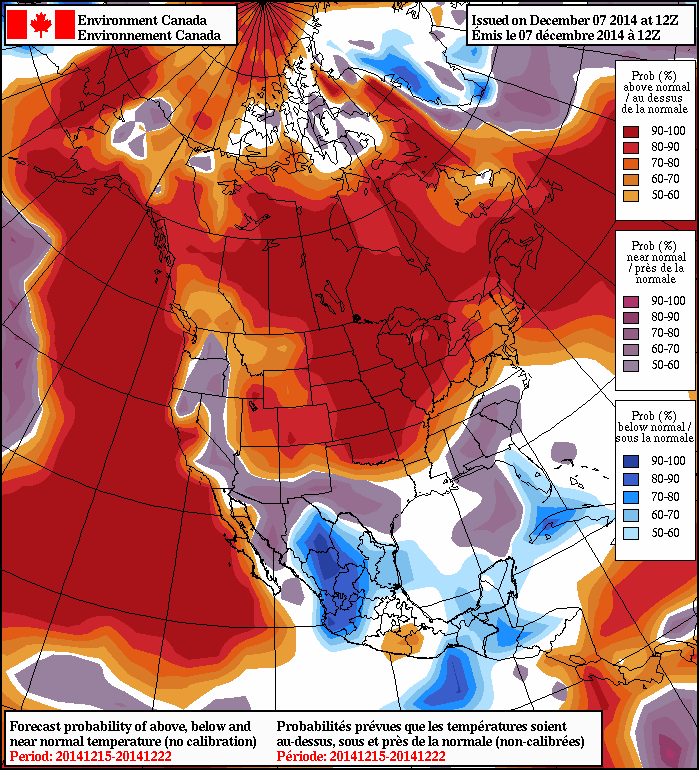
Through much of next week seasonal to slightly above seasonal temperatures are expect with no significant precipitation events in the forecast.


  1. Our daytime highs near -1°C are about 8°C above seasonal for this time of year.  ↩
  2. As shown in the figure mid-way through this post, while surface temperatures will struggle to climb just above 0°C, temperatures just 1.5km off the ground are nearly 17°C.  ↩

Mild Weather Returns, But Not The Sunny Spell Once Expected

Mild temperatures, above seasonal for this time of year, will be in place over Southern Manitoba, but the potential warmth will be limited over much of the Red River Valley and areas east thanks to an extensive area of low cloud that has moved into Manitoba and North Dakota within the outflow from a ridge of high pressure situated over Michigan.

Wednesday
-2°C / -3°C
Mainly cloudy & windy.
Thursday
0°C / -2°C
Mostly cloudy and mild
Friday
+1°C / 0°C
Mixed skies and mild

Today will be 7-8°C above seasonal for this time of year[1] with temperatures climbing to the -2 to -1°C mark by late this afternoon under cloudy skies. It will be moderately windy too with sustained wind speeds in the 30-40km/h range with gusts up to around 50km/h, making it feel like a much cooler day than it actually will be.

As the jet stream lifts northwards, warmer air lifts northwards as well.

The warming temperatures are thanks to a large upper-level ridge moving into the region which will develop an increasingly southwesterly flow across the Prairies and shift the jet stream further north. These two things together are helping push mild Pacific air into the southern Prairies. Unfortunately for Winnipeg, a ridge of high pressure anchored over Michigan will result in a persistent flow of colder air near the surface which, coupled with the cloud cover, will result in temperatures much lower than will be seen further west where a combination of more sun, terrain and some slightly more favourable wind directions will push temperatures towards record high territory.

Temperatures will barely drop tonight, perhaps just a degree or two, with winds tapering off to around 20km/h. The cloud cover will possible break up a little bit, but will likely remain cloudier than not.

Thursday will likely be another mostly cloudy day as the stratus continues to limit our daytime highs. We should see the temperature climb up to around 0°C with the southerly winds near 20km/h diminishing to light through the day. Thursday night will bring some scattering of the clouds, although mixed skies persisting until morning is the most likely situation at this point. Indications right now show that there may be a slight risk for freezing drizzle on Thursday night. Expect a low near -2°C.

Friday will be the nicest day of the three with a little sunshine looking a bit more likely than today or tomorrow. Temperatures will likely climb up to around 0 or +1°C, however if we end up with substantial amounts of sunshine, +2 or +3°C may even be possible.

Much Warmer over Western Manitoba

For areas in Western Manitoba, especially those on the northern side of the Turtle Mountains or those in the Dauphin area near the Riding Mountains, temperatures will be quite a bit warmer over the coming days. A combination of several factors, including:

  • Further proximity from the ridge over Michigan will minimize the amount of cold air being reinforced near the surface in a return flow.
  • Winds have a more southerly to slightly southwesterly component which will help tap the warmer air.
  • Terrain is not a valley that likes to keep cold air caught in it.
  • Downslope mixing on the northern side of larger terrain features will help couple the surface and warm air aloft.

This all means that for several days, beginning today, daytime highs will generally climb into the +2 to 5°C range for areas in the more generally open area to warmer values of +5 to +8 in regions downwind (north of) major terrain features such as the Riding Mountains or Turtle Mountains.

Warmth Spreads into the Red River Valley on the Weekend

The even warmer weather will spread into the Red River Valley for the weekend, however, as winds shift into a more southwesterly flow, helping push out the cold air and get some of that more substantial warmth into the region. Saturday looks to bring highs in the low-to-mid single digits with cooler air filtering in on Sunday, dropping highs back to the cooler side of 0°C alongside a chance for some light snow.


  1. The seasonal daytime high for Winnipeg this time of year is around -9°C.  ↩

Winter Takes a Vacation

Winter will take a vacation this week, as temperatures soar well above seasonal values.

Cooler temperatures are expected in southern Manitoba on Monday

Monday

Monday
-10°C / -20°C
Mainly cloudy with chance of flurries

Today will be our last taste of arctic air for awhile! High temperatures today will be around or just below -10C with a breezy north-west wind. There may be some light flurries during the day, particularly in the morning, but they shouldn’t amount to much, if anything.

Tuesday

Tuesday
-7°C / -8°C
Mainly Sunny

Tuesday will be a bit warmer than Monday, as a strong southerly flow brings warm air into southern Manitoba. High temperatures will be in the minus single digits, which is slightly above-normal for this time of year. The only downside is that it will be very windy, with south winds of 40km/h gusting to 60km/h. Temperatures will not decrease much on Tuesday night as that strong wind keeps conditions mild.

Wednesday

Wednesday
-2°C / -2°C
Mainly Sunny

High temperatures on Wednesday will approach or exceed the freezing mark in most of southern Manitoba. South-western sections of the province should reach the freezing mark, while areas in the Red River Valley and south-eastern Manitoba remain just below freezing. Winds will remain gusty and from the south.

Long Range

The NAEFS model suggests that above-normal weather will last through mid-December

The long range forecast is looking very good. Models are in strong agreement that our weather will remain above-normal for the foreseeable future. In fact, later this week temperatures will likely be well-above normal, with multiple days potentially being above freezing. There is no sign of any major cool-downs in the forecast – enjoy it while it lasts!

Elsewhere in Weather News: December 6th, 2014

Super Typhoon Hagupit Heads towards the Philippines

The Philippines are bracing for a very strong typhoon that is expected to make landfall this weekend. Hagupit, which was formerly known as a super typhoon (with winds exceeding 240km/h) has lowered in intensity but is still considered dangerous. The slight weakening was due to an eye wall replacement that took place. As of Friday afternoon, the typhoon was located in the West Pacific and heading west towards the central islands as well as the main islands where Manila is located.

This region has seen numerous strong typhoons in the last five years including super typhoon Haiyan, which made landfall in the Philippines 13 months ago just south of where Hagupit is expected to make landfall.

Hagupit looking more ragged as it approaches the Philippines after the eye wall replacement, however the bigger eye signifies a larger wind field. (Source: NOAA)

Yesterday, Hagupit had already begun lashing the islands with its outer rain bands. Evacuations were underway this past week where around 500,000 people have already been evacuated from areas most at risk including along small coastal fishing villages and in unsafe structures. The typhoon is expected to make landfall tonight near Sorsogon City, and will likely reach a high end category three or low end category four equivalent storm, bearing sustained winds of around 200km/h. Storm surges are sure to be a problem, especially along the front right quadrant of the typhoon, where surges could exceed 10 feet. Rainfall will also be of concern since Hagupit is fairly slow moving and will be able to drop copious amounts of rain. It is expected that the hardest hit areas, around where Hagupit makes landfall, could see around 500mm of rainfall.

After Hagupit emerges back over waters, the waters of the South China Sea, it is unclear as to where it will go and what its strength will be. A few of the forecast models show it holding together and continuing straight west with at least tropical storm force winds but sea-surface temperatures are not ideal for intensification in the region.