Warm weather will stick around until Christmas, a nice break for the holidays.
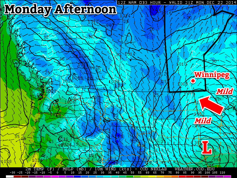
Mild conditions are expected in southern Manitoba on Monday
Monday
Monday
0°C / -4°C
Light snow
Today will be very mild, but with some snow. A low pressure system off to the south will generate some light snow in southern Manitoba during the day, with accumulations of generally around 2cm expected. Given the mild temperatures, most snow should melt quickly off treated roads, making for mostly wet, as opposed to slippery, conditions.
Tuesday
Tuesday
-1°C / -8°C
Light snow
More light snow is expected on Tuesday as the system to the south remains in place. Accumulations of around 2cm will once again be possible. Temperatures will remain mild though, making for a decent day.
Wednesday
Wednesday
-3°C / -10°C
Mainly cloudy with chance of flurries
A slight chance of flurries will linger on Wednesday, but any additional accumulations should be small. A breezy south wind will develop, keeping temperatures mild.
Long Range
Conditions should remain mild until Christmas, but after that a major pattern change is coming. Models suggest that our first major arctic blast in several weeks will move in on Boxing Day. That might have many folks doing their post-Christmas shopping online, as opposed to venturing out into an unfamiliar chill.
The NAEFS is predicting below-normal temperatures in the 8-14 day time period.
Another spell of above-normal temperatures are on the way to the Red River Valley this weekend with daytime highs possibly reaching above freezing by the beginning of next week. Closer to Christmas, temperatures will return to seasonal values before cooler air slumps southward for the end of December.
Friday
-6°C / -9°C
Cloudy with periods of light snow
Saturday
-4°C / -7°C
Cloudy
Sunday
-2°C / -4°C
Mixed skies with a chance of flurries
Today marks the beginning of the warmup as cloud ahead of an approaching warm front blankets the province almost entirely. Here in the Red River Valley, light snow will likely be fairly widespread thanks to favourable temperature profiles throughout the lower levels of the atmosphere. As is typical in these situations, don’t expect any real accumulation. Temperatures will climb to an above-seasonal –6°C or so with light winds. Temperatures dip down to around –9°C tonight with mainly cloudy skies.
Saturday will be another cloudy day with temperatures climbing to around –4°C under mainly cloudy skies. The main difference will be that light snow won’t be nearly as likely, although a few isolated flurries are possible. Winds remain light and temperatures dip to around –7°C on Saturday night under cloudy skies.
Sunday will start…you guessed it, mainly cloudy once again with temperatures beginning to edge even warmer; the daytime high on Sunday will likely be around –2°C. The cloud may begin to scatter out in the afternoon providing a brief reprieve from the cloudy skies.
Some flurries are once again possible, however any real threat for snow will hold off until the overnight hours where a low pressure system passing to our south will potentially bring a band of snow across the Red River Valley with a couple of cm accumulation.
Snowy(-ish) Return to Winter
Looking ahead to next week, the weather pattern will be dominated by a large low pressure system developing over the eastern half of the United States & Canada. The Red River Valley will be positioned on the back-side of the strengthening low, locking us into northerly winds that will begin pulling Arctic air southwards through the Prairies.
The GFS 850mb temperature forecast valid on Christmas eve shows a trough of cold air plunging southeastwards behind a strongly tilted, major storm system centered over Ontario.
With the cooler air plunging southwards, daytime highs will cool off to the mid-minus teens for the second half of the week. Snowfall is a little uncertain at this point for us, but it doesn’t look like much will be seen here, making for a cool and blustery, but not particularly stormy, Christmas. It is worth noting that this storm system will have dramatic impacts on the eastern half of the country, including Toronto & Montreal, so if you have travel plans for the holidays that involve flying in that direction, be prepared for potential delays.
The weather pattern that has brought temperatures well above seasonal to Winnipeg[1] – despite the persistence of low cloud supplied by the outflow winds of a high pressure system to our southeast – will continue to pump warm Pacific air eastwards into the region for another couple days. By the end of the weekend, however, a cold front is set to push through bringing more seasonal temperatures back to the Prairies.
Friday
1°C / -2°C
Mainly cloudy
Saturay
3°C / -3°C
Mixed skies
Sunday
-1°C / -13°C
Mainly cloudy; slight chance of flurries
Winnipeg will see cloudy weather today as low cloud entrenched in the Red River Valley refuses to exit as southerly outflow winds continue to reinforce the low-level moisture trapped underneath the substantially warmer air just off the surface[2] that has spread over southern Manitoba.
The cloud will be accompanied by breezy southerly winds to 30-40km/h. The temperature will only climb to around 0 or +1°C today. Some clearing is possible later in the day as drier air begins pushing eastwards into the Dakotas and may work its way northwards in the flow. It’s far from certain, but we could see some breaks in the cloudy skies later today into the evening. Temperatures will drop to around -2°C tonight.
This Winnipeg forecast sounding – valid at 10AM CST Friday, December 12, 2014 – shows a thin layer of saturated air right at the surface which will continue to produce low-level cloud.
Saturday looks to bring mixed skies with a lot of uncertainty on exactly what we’ll see. Weather models want to clear things out fairly well and give us sunny skies with a high near 6°C. Unfortunately, I’m not entirely convinced that’s what will happen. The Red River Valley will sit on the cusp of where the return flow from the high pressure system meets drier air pushing in from the southwest. However, a low pressure system approaching from the west will likely back the winds slightly, tapping into the low-level moisture in the outflow winds from the high. Additionally, large-scale lift ahead of the low could also work to develop more low cloud ahead of the approaching cloud. So while the day may end up sunny, it seems a bit more likely we’ll see mixed skies or increasing cloud through the day. Due to that, I think the high will be closer to 3 or 4°C with temperatures dropping to around -3°C overnight under mainly cloudy skies.
Sunday will be a mainly cloudy day as a low pressure system passes to our south. Northwesterly winds will bring more seasonal Arctic air into the region through the day, limiting our daytime highs to -1°C with just a slight chance for some light flurries.
Through much of next week seasonal to slightly above seasonal temperatures are expect with no significant precipitation events in the forecast.
Our daytime highs near -1°C are about 8°C above seasonal for this time of year. ↩
As shown in the figure mid-way through this post, while surface temperatures will struggle to climb just above 0°C, temperatures just 1.5km off the ground are nearly 17°C. ↩
Mild temperatures, above seasonal for this time of year, will be in place over Southern Manitoba, but the potential warmth will be limited over much of the Red River Valley and areas east thanks to an extensive area of low cloud that has moved into Manitoba and North Dakota within the outflow from a ridge of high pressure situated over Michigan.
Wednesday
-2°C / -3°C
Mainly cloudy & windy.
Thursday
0°C / -2°C
Mostly cloudy and mild
Friday
+1°C / 0°C
Mixed skies and mild
Today will be 7-8°C above seasonal for this time of year[1] with temperatures climbing to the -2 to -1°C mark by late this afternoon under cloudy skies. It will be moderately windy too with sustained wind speeds in the 30-40km/h range with gusts up to around 50km/h, making it feel like a much cooler day than it actually will be.
As the jet stream lifts northwards, warmer air lifts northwards as well.
The warming temperatures are thanks to a large upper-level ridge moving into the region which will develop an increasingly southwesterly flow across the Prairies and shift the jet stream further north. These two things together are helping push mild Pacific air into the southern Prairies. Unfortunately for Winnipeg, a ridge of high pressure anchored over Michigan will result in a persistent flow of colder air near the surface which, coupled with the cloud cover, will result in temperatures much lower than will be seen further west where a combination of more sun, terrain and some slightly more favourable wind directions will push temperatures towards record high territory.
Temperatures will barely drop tonight, perhaps just a degree or two, with winds tapering off to around 20km/h. The cloud cover will possible break up a little bit, but will likely remain cloudier than not.
Thursday will likely be another mostly cloudy day as the stratus continues to limit our daytime highs. We should see the temperature climb up to around 0°C with the southerly winds near 20km/h diminishing to light through the day. Thursday night will bring some scattering of the clouds, although mixed skies persisting until morning is the most likely situation at this point. Indications right now show that there may be a slight risk for freezing drizzle on Thursday night. Expect a low near -2°C.
Friday will be the nicest day of the three with a little sunshine looking a bit more likely than today or tomorrow. Temperatures will likely climb up to around 0 or +1°C, however if we end up with substantial amounts of sunshine, +2 or +3°C may even be possible.
Much Warmer over Western Manitoba
For areas in Western Manitoba, especially those on the northern side of the Turtle Mountains or those in the Dauphin area near the Riding Mountains, temperatures will be quite a bit warmer over the coming days. A combination of several factors, including:
Further proximity from the ridge over Michigan will minimize the amount of cold air being reinforced near the surface in a return flow.
Winds have a more southerly to slightly southwesterly component which will help tap the warmer air.
Terrain is not a valley that likes to keep cold air caught in it.
Downslope mixing on the northern side of larger terrain features will help couple the surface and warm air aloft.
This all means that for several days, beginning today, daytime highs will generally climb into the +2 to 5°C range for areas in the more generally open area to warmer values of +5 to +8 in regions downwind (north of) major terrain features such as the Riding Mountains or Turtle Mountains.
Warmth Spreads into the Red River Valley on the Weekend
The even warmer weather will spread into the Red River Valley for the weekend, however, as winds shift into a more southwesterly flow, helping push out the cold air and get some of that more substantial warmth into the region. Saturday looks to bring highs in the low-to-mid single digits with cooler air filtering in on Sunday, dropping highs back to the cooler side of 0°C alongside a chance for some light snow.
The seasonal daytime high for Winnipeg this time of year is around -9°C. ↩

")

