“Normal” weather will continue over the next few days as a ridge of high pressure builds into the Eastern Prairies, bringing us plenty of sun and daytime highs in the mid-to-upper 20’s. Before that, though, we’ll see a slight chance of showers this afternoon. A trough of low pressure is forecast to push into Manitoba on Saturday, bringing with it a chance of rain.

GEM-GLB surface winds valid on Thursday morning. A very large ridge is the dominant feature over the Eastern Prairies.
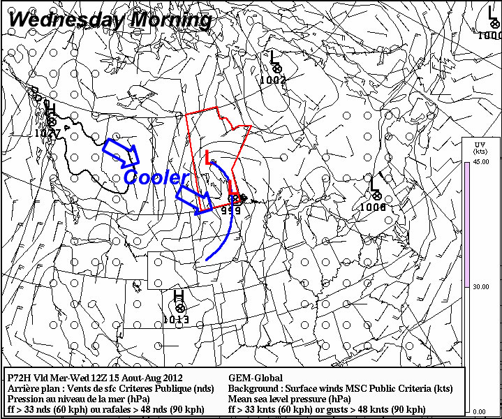
There is a very slight chance of a shower or two over the Red River Valley this afternoon as a trough of cold air digs southwards as it heads east out of the province; the best chances should remain to our east, through the Whiteshell and Berens River regions, but it certainly can’t be ruled out for us. Accumulations will be minimal and the showers will dissipate fairly early in the evening.
A strong ridge will continue building in across the Northern/Eastern Prairies, forecast to strengthen to a 1028mb high by tomorrow morning, with the ridge axis extending from the Red River Valley NE into Hudson Bay/James Bay. This feature will ensure fairly sunny skies over the next couple days, limiting clouds to just some shallow fair-weather cumulus, as well as induce a broad southerly flow over Manitoba. This would normally result in hot temperatures and high humidity, but in this case, it’s actually going to result in…well, more of the same. The reason for this is significant: instead of being a high pressure system created by an upper ridge, this will be a high pressure system created by a cold trough of air descending from the Arctic. The southerly flow that will develop over the province, instead of being a flow of warm, moist air from the Gulf of Mexico, will be a return flow of air out of the high. So while we’ll have sunny skies, our temperatures will only creep up little by little, and our dewpoints will only climb into the low-to-mid teens.
It’s also worth noting that as crops mature, we’ll be significantly less likely to see days with very high dewpoints (20°C+) for two reasons:
- When plants mature, the evapotranspiration (ET) rate dramatically diminishes. Corn, for example, will ET up to 0.33“ per day at peak growth rate. That value then diminishes to 0.23” at maturity. Mature trees may ET up to 50 gallons of water each day during the growing season. Again, this value diminishes in late-summer when all the growth has become mature. Most plants follow similar patterns.
- The crushing drought through the Central US will diminish pretty much any advection of moisture that may occur. There’s a long way between us and the Gulf of Mexico, and the normal ET contributions from plants through the Central Plains is missing this year.
One of the side effects to this is that our severe thunderstorm season will likely come to a fairly rapid halt over the coming weeks as good setups become moisture-starved.
Evapotranspiration is the process by which plants take up moisture from the soil and expel it as vapour into the atmosphere through the stomata on their leaves.
For Saturday, it currently looks like a trough of low pressure will work it’s way across the province, bringing with it a chance for showers. The track is highly dependent on the positioning of an upper low over the northwestern Prairies, so it’s a little early to say where exactly precipitation will fall. Either way, it doesn’t look to be very powerful, and any areas that see precipitation look to receive small amounts.
The next chance for rain looks to be not until the middle of next week.
July 2012 Closes Out as 5th Hottest
July 2012 closed out as an extremely warm month. The average temperature for the month was 22.3°C, 2.7°C above the normal 19.6°C. This places July 2012 in 5th place for all-time hottest July:
Warmest Julys on Record
|
Year |
Average
Temperature |
| 1 |
1936 |
24.2°C |
| 2 |
1935 |
22.4°C |
| 3 |
1916 |
22.4°C |
| 4 |
1914 |
22.4°C |
| 5 |
2012 |
22.3°C |
The warmest day we had was July 11th, which reached 34.5°C. Our coolest day was July 15th, where the mercury topped out at only 19.4°C. Our warmest overnight low was 20.5°C on the night of July 10th/11th. Our coldest overnight low was 7.9°C on the night of July 26th/27th. In total, the Winnipeg Airport recorded 14 days with temperatures above 30°C in July. The hottest day in July on record is 42.2°C set in 1936. The coldest night on record in July is 1.1°C set in 1972.
The biggest story was, perhaps, the sheer lack of rainfall last month. The airport recorded 23.5mm of rain, which is the 11th driest July on record:
Driest Julys on Record
|
Year |
Amount |
| 1 |
2006 |
10.5mm |
| 2 |
1875 |
13.5mm |
| 3 |
1925 |
15.5mm |
| 4 |
1894 |
16.0mm |
| 5 |
1886 |
17.0mm |
| 6 |
1960 |
17.0mm |
| 7 |
1920 |
19.3mm |
| 8 |
1910 |
20.3mm |
| 9 |
1964 |
22.4mm |
| 10 |
1979 |
23.1mm |
| 11 |
2012 |
23.5mm |
July 2012 was the 7th driest July in the last 100 years. Fortunately, the drought wasn’t as hard hitting as areas further south, as Winnipeg had several months preceding July with above-normal precipitation.
As we covered on Monday, August looks to be off to a dry start with daytime highs sitting near-normal to just above normal.